HiRISE GIS tools and other stuff
Here are a couple of useful things for HiRISE team members. Mostly, I wrote this stuff to be useful to me so in some cases it's generally useful, but in others it's not.
- HiSTARE - See the status of stereo observarions for each theme.
- Code to generate stereo_summary webpage - stereo_summary.pl
Shapefiles of processed observations, planned (and unprocessed) observations and suggested observations etc... The data in these shapefiles are taken from the HiCAT database.
| Processed observations | obs_geom.tar.gz | Last Modified Wednesday, 27-May-2009 15:23:16 MST |
| Planned (and unprocessed) observations | plan_geom.tar.gz | Last Modified Wednesday, 27-May-2009 15:23:16 MST |
| Suggested observations | hicat_dump.tar.gz | Last Modified Wednesday, 27-May-2009 15:23:14 MST |
| Note: these were generated with ographic latitudes (changed on 3/16/2009). | ||
- Code to generate shapefile of geometrically processed observations - obs_geom.pl
- Code to generate shapefile of planned (and unprocessed) observations - plan_geom.pl
- Code to generate shapefile of suggested observations - dump_hicat.pl
To run these you'll need a HiCAT username and password. To get around the UA firewall you'll need a PIRL username and password.
Grabbing the HiRISE browse images and automatically writing world files can be done with this PERL script. Right now the SQL query is designed to catch polar images, you'll have to update that line of code if you want different are as.
Importing a flat textfile of targets into HiCAT can be done with this script.
- Label describing the flatfile format hirise_target_import_v1.0.lbl
- PERL script to import the flatfile table into HiCAT hirise_target_import_v1.0.pl
Rod needs to run the script since he's the only one with direct write permissions to HiCAT. There are some tools available to create HiRISE targets in ArcMAP projects and export them in this flatfile format.
- Example personal geodatabase to store the targets HiCAT_geographic_targets.mdb
- Python script to export geodatabase to flatfile written by Trent Hare: MRO_HiCAT_Export_slim.py(new version posted 5/1/2008)
- GUI to run the python script written by Trent Hare: MRO_HiCAT_Tools_slim.tbx
So you can go directly from ArcMAP to HiCAT when selecting targets without using HiWEB. Like in the screenshot below...
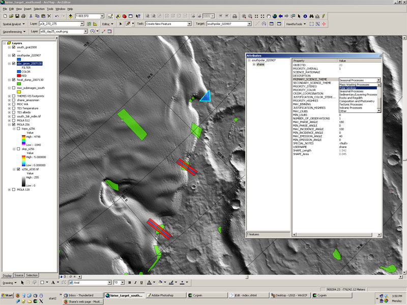
- Red/Blue strips are the HiRISE footprints
- Green polygons are the HiCAT target suggestions
- Blue polygons are the targets being created by the user