From Points of Light to Worlds: UA Explores the Solar System
A determined bunch of scientists set out to map the moon in preparation of the Apollo landings, but that was only the beginning. A new field of science blossomed, and UA scientists have been involved in nearly every U.S. space mission since.
By Daniel Stolte, University Communications - July 3, 2019
Here's a fun thought: Imagine if University of Arizona scientists got to keep a replica of the spacecraft for every space mission in which they've been involved.
The collection of space-faring gadgets they would have amassed by now likely would fill all five stories of the UA's Kuiper Space Sciences Building. Tourists from around the world would flock to campus, drawn by an array unlike any other, bristling with space probes, robotic rovers, extraterrestrial telescopes, glinting satellites and other ingenious apparatuses designed and launched over the past half-century of space exploration.
From Probes to Planetary Science
The first exhibit a visitor to our imaginary exhibit of space memorabilia would come across is Ranger, a series of lunar reconnaissance probes designed to record high-resolution images of the lunar surface during a descent ended by a deliberate crash-landing.
Next would be Surveyor, a series of three-legged, solar-panel-topped contraptions NASA sent to the moon between 1966 and 1968 to test the feasibility of soft landings on the moon's sea of dust. Both missions have deep ties to the beginnings of planetary science at the UA.
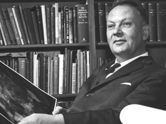
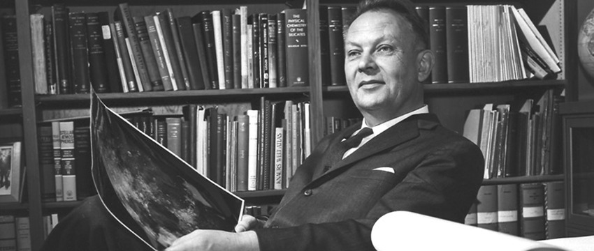
Not many people can say they were there when a new area of science was born, but Steve Larson can. Larson first got his feet wet – or rather, his boots dusty – trotting across lava fields and volcanic craters during field trips as one of the first freshmen to study planetary science at the UA, soon after Gerard Kuiper founded the university's Lunar and Planetary Laboratory, or LPL.
Ranger and Surveyor were crucial in paving the way for the first manned moon landing in at the end of the decade, and NASA enlisted the help of Kuiper and Eugene Shoemaker, a contemporary planetary scientist who served as the first director of the United States Geological Survey's Astrogeology Research Program.
"Those two were the only people who knew about this stuff," Larson says. "They agreed that Kuiper would do Ranger, and Shoemaker would do Surveyor."
Larson remembers being in Kuiper's' office once with Shoemaker there. Spread out on the table was a large print of the moon surface.
"Kuiper was used to observing through telescopes, so he wanted south to be up, and Shoemaker worked with maps, so he wanted north to be up," Larson says. "They ended up standing at opposite ends of the table, pointing out features on the map, and both were perfectly happy."
The episode illustrates how planetary science came into existence – through an enthusiastic, at times rocky, marriage of disciplines that traditionally didn’t have much to do with each other. Astronomers who knew how to operate telescopes were needed just as much as geologists who understood the inner workings of planetary bodies; physicists and engineers were crucial in inventing and advancing various methods of imaging and detection, as well as chemists adept at teasing out mineral compositions from meteorite samples.
"At that time it was only LPL, there was no Department of Planetary Sciences," says William Hubbard, one of the first faculty Kuiper hired when he established an academic department. " thought that in order to ensure the longevity of the whole enterprise, we needed an academic arm – we needed to have graduate students, we needed to have a teaching program."
Hubbard, who was trained as an astronomer, remembers teaching the first planetary science course offered to undergraduate students. Unsure of what such a course should entail, Hubbard teamed up with Mike Drake, a young and energetic colleague who, like Hubbard, would later serve as department head. Each would teach half of the course, and to help each other evaluate and improve their teaching, the two sat in on each other's lectures to observe.
"After I had sat through one of Mike's lectures, I said, 'Gee, I didn’t' know all this stuff,'" Hubbard says, "and Mike just laughed and said the same about my lecture. That taught us we had to be more aware of what other departments and other disciplines were doing."
Hubbard dedicated much of his career to unlocking the inner workings of planets in the outer solar system such as Jupiter, and although formally retired, he is involved with NASA's Juno spacecraft.
Send the Machines
Juno's replica would be a commanding sight: The furthest venturing craft to rely on the sun for power, Juno is mostly solar panels that loom overhead like a windmill, large enough to cover a basketball court.
After Juno, tucked into a corner of the the LPL's imaginary hall of fame is what looks like a shoebox with an upside-down tripod mounted on its top. Built by Charles Sonett, the instrument, a magnetometer, traveled to the moon with Apollo 16 and gathered clues about the moon's core.
In 1973, Sonett had been invited by Kuiper to succeed him as the director of the LPL and first head of the newly minted planetary science department. Sonett was involved in spacecraft missions that dramatically advanced our understanding of the solar system and beyond, including the Pioneer, Explorer and Apollo programs. He is credited for expanding the LPL's research into cosmic riddles that could only be solved by sending robotic explorers out to space to investigate phenomena such as interplanetary plasma, a soup of particles, cosmic rays and dust embathing the solar system.
Planetary science had come into its own. Larson, one of the new department's first students and now a senior staff scientist at the LPL, remembers what he calls "electrifying times."
"If you wanted to study anything in the solar system, the UA simply was the place to be," he says. "Our planets evolved from points of light to actual worlds, and LPL has driven that evolution. When I first started, we looked at the points of light, and they became little discs. Now, a half century later, we land on them, we dig on them, and we bring samples back to Earth."
The plethora of spacecraft in the LPL's imaginary museum would bear witness to the story of how discs of light, one by one, were turning into worlds with exotic interiors, alien atmospheres and – in some cases – menageries of moons.
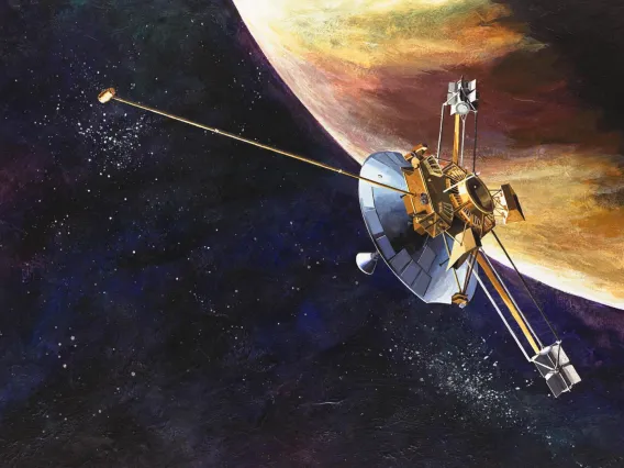
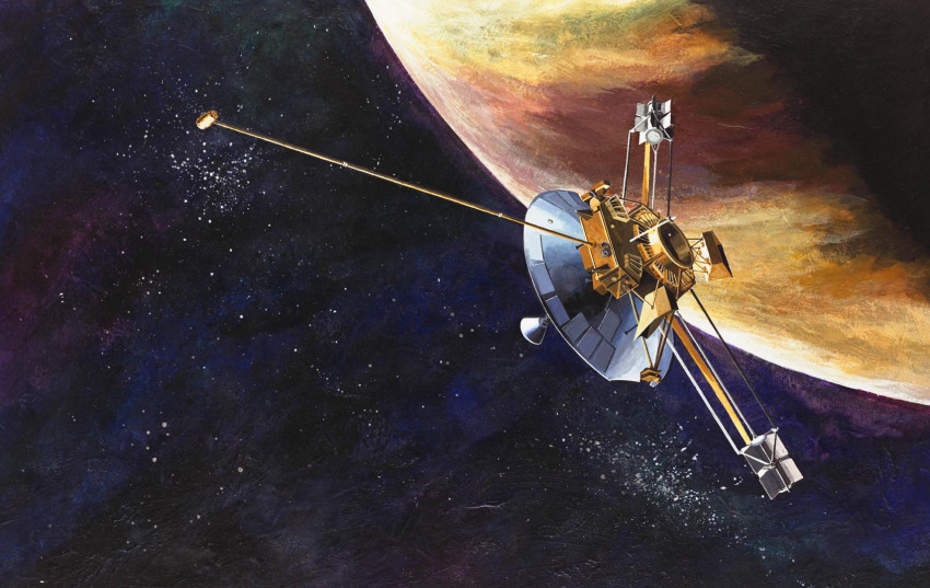
There was Pioneer, with its famous golden plaque sporting depictions of human figures in what was meant to be a greeting to other civilizations should any ever encounter the spacecraft. As the probe flew by Jupiter and Saturn, its spin swept a photopolarimeter, developed by former LPL professor Tom Gehrels, across the planets, assembling the first close-up images of the giant planets.
There were the Voyager probes, bearers of the famous "golden record." Voyager 2 took the only close-up images we have of Uranus and Neptune to this day, and its twin, Voyager 1, became the first manmade object to leave the solar system. The imaging team was led by former LPL professor Brad Smith.
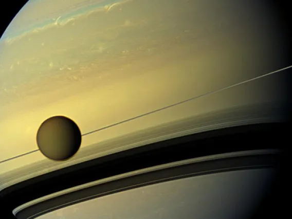
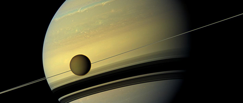
Further down the hall would be Cassini-Huygens. A towering probe the size of a school bus, Cassini-Huygens brought the exquisite, otherworldly beauty of Saturn and its moons to desktop wallpapers worldwide. Many UA planetary scientists and their students were directly involved in this mission, which included the first landing on a moon other than Earth's. The descent imager aboard the Huygens lander, developed by an LPL team led by Martin Tomasko, captured its descent through the thick, hazy atmosphere of Saturn's moon Titan onto a frozen, alien landscape, including lakes of liquid methane.
Titan is also the target of Dragonfly, NASA's newly selected New Frontiers mission. Dragonfly will send a quadcopter drone to look for signs of life the icy moon's origins. The mission team includes – you guessed it – many former UA planetary science students.
"The first time you go to one of these places, you learn a lot," says current LPL Director Tim Swindle. "It's completely different from what you thought you knew from when you looked at it from afar. At LPL, we have been part of many of those first looks at these worlds."
Back to the Moon and on to Mars
Swindle is excited about the possibilities the next 50 years may hold in store for planetary exploration.
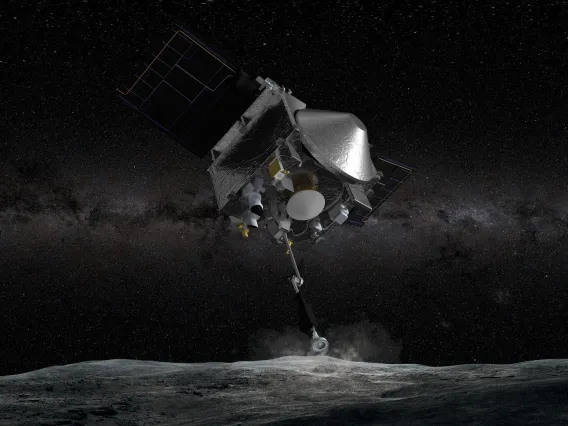
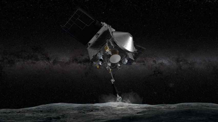
"We are going back to the moon, where we'll be doing all sorts of new experiments on the surface," he says. "The things we are doing right now with OSIRIS-REx to prepare for sample return from asteroid Bennu are the same things we'll be doing to prepare to bring back samples from Mars."
Swindle also is confident that LPL programs, which have found about half of the known near-Earth asteroids, will continue to lead the way in discovering more.
"Once we start further exploring asteroids, we'll send mining robots rather than exploration robots," he says, "and perhaps some day, even people. I think LPL will be a part of all that."
Who knows, 50 years from now, a space exploration museum on the UA campus may be a reality, as well. Until then, visitors to the Charles P. Sonett Space Science building, across the street from Flandrau Science Center & Planetarium, can peer down the telescope barrel on a life-size model of the UA-led HiRISE camera, which has been photographing Mars in stunning detail for more than 10 years.
Learn more about the Lunar and Planetary Laboratory's space exploration efforts in the current and former space mission rosters.
Undergraduate Students at Work on OSIRIS-REx
When she’s not in class or training to qualify for next year’s Boston Marathon, you can find undergraduate Stephanie Stewart hard at work with her teammates on OSIRIS-REx, NASA’s first asteroid sample return mission.
By Emily Litvack, Office of Research, Discovery & Innovation - June 28, 2019
Stephanie Stewart’s work on the University of Arizona-led OSIRIS-REx mission began in earnest in February, soon after the NASA spacecraft arrived at its destination, the asteroid Bennu.
Stewart learned about the OSIRIS-REx mission through her roommate Natalie Schultz, a UA student majoring in optics and engineering and a researcher for the mission. As someone who was passionate about data systems, Stewart wanted to contribute to NASA’s first mission to collect rocks and dust from an asteroid and bring it back to Earth. She figured a feat like that must involve lots and lots of data.
Right she was. The UA undergraduate, now a junior majoring in management information systems at the Eller College of Management, joined a team tasked with ensuring a flawless five-second operation to collect and stow away dust from the surface of Bennu. The team’s job: Scouring image after image of Bennu, looking for a spot to land.
“The entirety of the OSIRIS-REx mission is breathtaking and inspiring,” Stewart said. “After this mission, we will have samples of Bennu here on Earth that we can use to further piece together the profound history of our solar system.”
Q: What do researchers hope to learn by studying rocks and dust from the surface of Bennu?
Stewart: Although there are several objectives for this asteroid sample return mission, gaining a deeper understanding of how planets formed and life began is at the forefront. Our solar system has millions of asteroids, but Bennu is classified as a near-Earth asteroid and is therefore easier to access. Due to their considerably ancient existence, asteroids can provide us with a better understanding of the building blocks of our solar system and the creation of Earth. One thing to remember is that up until now, we have used instruments that have only been calibrated to samples here on Earth. After obtaining samples and more data from Bennu, we can have a better understanding of the accuracy of our instruments in measuring items that are far away.
Q: What’s the next big milestone for the OSIRIS-REx mission and what will be your role in it?
A: The OSIRIS-REx team is in the process of narrowing the original 50 regions of interest to just a handful of possible landing sites. When we originally started this mission, researchers assumed that the ideal areas would be instantly visible, but as we approached Bennu, we realized this wasn’t the case. Ideally, the landing site should have sand-sized samples, but finding an area with rocks the size of a couple centimeters has been a challenge. Looking ahead, we will be obtaining more detailed images and comprehensive data of the potential sites so that we can narrow the region of interest to one. When a final area is chosen, we will collect even more detailed images and data.
Q: You work on the team identifying a "safe" place to collect samples of the asteroid Bennu. How does the team go about figuring out what’s safe?
A: I specifically work with boulder identification, meaning I look at sites of interest and take note of the number, clustering and size of the rocks in a particular area. As Keara Burke, a systems engineer and data analyst for the mission, explained, the Touch-And-Go Sample Acquisition Mechanism, or TAGSAM, can only collect rocks up to about three-quarters of an inch in dimeter. Rocks larger than 21 centimeters can block the entire collection head, and rocks taller than five centimeters can cause the TAGSAM to tilt, affecting how much the chamber can collect. Therefore, it is imperative that boulder identification is both accurate and precise for this mission to be successful.
Q: Did the mission doing anything special to celebrate Asteroid Day this year?
A: Yes! Dolores Hill, the co-lead of the OSIRIS-REx Target Asteroid Program, gave a presentation titled “OSIRIS-REx Encounters Asteroid Bennu” at the UA’s Flandrau Science Center and Planetarium on Sunday, June 30. She talked about the exciting new science that has been discovered since the OSIRIS-REx spacecraft has reached Bennu. She also explained the surprises encountered since the spacecraft’s arrival this past December, the next steps for sample acquisition, and the TAGSAM that will be used for the five-second collection.
How the UA Guided Men to the Moon
The maps and images created by a small UA team at the start of the space race opened the door for lunar and planetary exploration 50 years ago.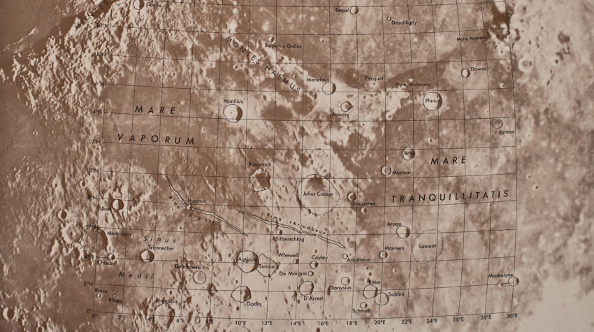
By Mikayla Mace, University Communications - June 26, 2019
Only a handful people were seriously studying the moon when President John F. Kennedy announced in 1961 that Americans would walk on its surface by the decade’s end. Among them was a small group of researchers at the University of Arizona.
The UA team imaged and mapped the lunar surface, which allowed them to understand the moon’s geology and NASA to choose landing sites for future robotic and Apollo missions. Gerard Kuiper, the father of modern-day planetary science, led the team and established the UA Lunar and Planetary Laboratory.
“Classic astronomers regarded the moon as an annoyance that lit up the night sky, making it hard to study the faintest stars and galaxies,” said William Hartmann, one of Kuiper’s first graduate students and co-founder of the Planetary Science Institute, or PSI, in Tucson. Hartmann and PSI co-founder Don Davis, another UA alumnus, also proposed that the moon was born from a giant impact with the Earth. Their theory still leads thinking today.
“Back then, astronomers were interested only in objects outside our solar system,” Hartmann said. “To most 1950s astronomers, the planets did not seem very interesting, and there weren't very useful techniques for studying them.”
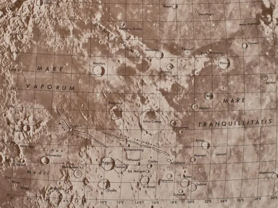
Moreover, moon maps at the time were drawn by hand, and the names of many features remained unsettled.
Kuiper, already a leader in planetary science by the time he arrived in Tucson in 1960, sought to understand Earth’s celestial neighbor and worked for years to create multiple lunar atlases with the best photographs of the moon.
The Lunar Atlases
Kuiper and his team collected the best available telescopic photos of the moon from observatories around the world and used them to produce the first two atlases while working at the University of Chicago’s Yerkes Observatory in Wisconsin. The Photographic Lunar Atlas and the Orthographic Atlas of the Moon, which included a coordinate grid, were published in 1960 and 1961, respectively. Astronomers used these while observing the moon telescopically.
The Rectified Lunar Atlas, published in 1963 by the University of Arizona Press, went a step further. The third atlas allowed humans for the first time to see what features on the moon’s edges, called limbs, looked like without distortion.
To accomplish this, Kuiper mounted a 3-foot-wide white hemisphere at the end of a hallway and projected glass plate photographs of the best images of the moon onto it. Hartmann, a first-year graduate student at the time, was tasked with snapping photos of the hemisphere from different angles. The resulting images revealed lunar features as they would appear from the perspective of an astronaut flying overhead.
Four years later, Kuiper produced yet another lunar atlas.
“The 1967 Consolidated Lunar Atlas was the last in the series of Gerard Kuiper,” said Steve Larson, who was one of Kuiper’s undergraduate research assistants and is now a senior staff scientist at the UA Lunar and Planetary Laboratory, or LPL. Larson established the Catalina Sky Survey and has worked under every LPL director since the lab’s inception.
The fourth atlas was comprised of the highest resolution images taken from the ground, most of which were taken using the NASA-funded 61-inch telescope perched atop Mount Bigelow in the Catalina Mountains north of Tucson. The telescope is now managed by the UA's Steward Observatory and bears Kuiper’s name.
“That was our main project for the first couple years after the construction of the 61-inch telescope,” Larson said. “We were funded by NASA to record high resolution images of the moon, but we also took images of Venus, Mars, Jupiter and Saturn to monitor changes in atmospheres."
Kuiper and his team created the Consolidated Lunar Atlas by carefully focusing the telescope on the moon and systematically snapping thousands of film photos along the moon’s terminator, the boundary between sunlight and darkness. At the terminator, sunlight hits the moon at a low angle, allowing the scientists to capture subtle variations in the lunar topography, Larson said.
But the high contrast and dramatic lighting near the moon’s terminator made imaging the lunar surface features tricky. Larson and undergraduate John Fountain laboriously brightened the areas near shadow and dimmed the brighter parts of the surface by hand.
“It was very analog,” he said. “I spent the whole summer monsoon season down in the basement dark room; The sun was shining when I went down, and when I came out it’s flooding everywhere.”
Kuiper and his team inspected, cataloged and graded each of the more than 8,000 film photos to whittle them down to the more than 200 which now comprise the Consolidated Lunar Atlas. It was published by the University of Arizona Press in 1967.
Landing the Eagle
At the same time, leaders at NASA knew they needed to understand the surface of the moon in detail to choose a landing site. Would the smooth, dark swaths of lunar surface – called maria, which means seas, as the earliest observers thought they were oceans – swallow the astronauts in dust or support them as cooled and solidified oceans of magma?
“When NASA was deciding where to land, they’d be looking at one of these prints. Here’s a spot with not a lot of craters that’s relatively flat,” Larson said as he pointed to the final Apollo 11 landing site, located in the Sea of Tranquility.
There are two main types of terrain on the moon, said LPL professor and planetary science assistant director Shane Byrne.
"Most of the Apollo missions and most of the Surveyor (lander) missions went to one type: the lunar mare, the dark areas of the moon," Byrne said. "It's smoother and safer to land there, and that was the motivation for sending the astronauts there. But most of the moon is covered with the bright areas, the lunar highlands, which are much rougher, much more cratered."
Before Men, There Were Robots
NASA prepared three series of robotic spacecraft to visit the moon ahead of the astronauts: Ranger, Surveyor and Lunar Orbiter.
NASA appointed Kuiper as chief experimenter, a position today referred to as principal investigator, on the Ranger missions. Among the team were UA planetary scientist Ewen Whitaker and Eugene Shoemaker, who created the astrogeology branch of the United States Geological Survey in Flagstaff, Arizona.
Ranger 1 launched August 1961 to collect video of increasing detail before crash-landing on the moon. Future Ranger missions failed until the 1964 launch of Ranger 7, which landed in what Kuiper dubbed Mare Cognitum, the Sea That Has Become Known. Whitaker selected the landing sites for Ranger 6 and 7.
The successful Ranger 7 mission improved the resolution of lunar detail 1,000 times over, Kuiper proclaimed at a press conference shortly after the spacecraft reached the moon.
To analyze the photographs, Kuiper partnered with UA professors emeritus Robert Strom of LPL and Spence Titley, of the Department of Geosciences. Titley gave Kuiper’s students and NASA’s astronauts crash courses in geology and recommended features the astronauts should photograph from orbit. Titley also worked with the U.S. Geological Survey in 1964 to map the moon using the McMath-Pierce Solar Telescope on Kitt Peak for the Apollo program.
The Ranger missions were followed by Surveyor 1, the first of seven unmanned lunar landers in a program that ran from June 1966 through January 1968. Surveyor 1 reached the surface of the moon on June 2, 1966, and sent back panoramic photos from its travels.
Surveyor’s success reassured the astronauts they would not be swallowed by dust. Despite the success of the Surveyor program, NASA had no way of knowing where, exactly, on the moon the spacecraft landed.
NASA published what they thought was the correct landing site in the journal Science. But Whitaker noticed a discrepancy, and after poring over images taken by NASA Lunar Orbiter, he published an alternate location for Surveyor 1 in the journal’s September issue.
“Whitaker was able to pinpoint the landing area by looking at mountain peaks on the horizon,” Larson said.
NASA officials realized their mistake and Whitaker’s skills earned him the task of locating four more Surveyor landing sites.
Whitaker again proved his prowess of the lunar surface when he correctly located Apollo 11. The first manned mission didn’t hit its intended target because the site was too rocky. The lander carrying the two men cruised for four additional miles, nearly running out of fuel before it touched down. NASA anlyzed photos taken from the surface and determined what they believed to be the Apollo 11 landing site. Ewen did his own analysis, which was contrary to NASA's location, and was correct.
NASA then sought to demonstrate a pinpoint landing with Apollo 12 and used Whitaker’s location of Surveyor 3 to do so. Whitaker’s location was so spot on that the astronauts walked to Surveyor 3.
Since the Apollo missions, the UA has imaged the surface of Mars in great detail using the High Resolution Imaging Science Experiment aboard the Mars Reconnaissance Orbiter. The UA also led the team that imaged the surface of Saturn’s moon Titan from under the clouds with the Cassini-Huygens probe. The UA is also heading up the OSIRIS-REx sample-return mission to the asteroid Bennu and is currently mapping and imaging the dark surface to choose a collection site.
Ion Beams and Atom Smashers: Secrets of Moon Rocks
Moon samples collected by the Apollo astronauts a half-century ago hold answers to questions that weren't even on scientists' minds at the time, as new technological tools provide insight into some of the oldest mysteries about the moon, the earth and the solar system.
Moon samples collected by the Apollo astronauts a half-century ago hold answers to questions that weren't even on scientists' minds at the time, as new technological tools provide insight into some of the oldest mysteries about the moon, the earth and the solar system.
By Daniel Stolte, University Communications - June 18, 2019
On July 20, 1969, as Apollo astronaut Neil Armstrong climbed down the ladder from the "Eagle" lunar landing module, he found himself surrounded by a sea of grey – an expanse of powdery dust no human had ever seen in person. The iconic print made by his left boot marked but the first step on a long journey of discovery, a discovery about the moon and our own world – both of which hold secrets that scientists are only beginning to uncover.
Fifty years after the Apollo astronauts collected samples of moon rocks and dust during their forays across the lunar landscape, there are still mysteries to be solved, and one University of Arizona scientist is looking for answers. Jessica Barnes, an incoming assistant professor in the UA's Lunar and Planetary Laboratory, was recently selected by NASA to receive access to preciously unopened moon rock samples.
Under NASA's Apollo Next Generation Sample Analysis, or ANGSA, program, Barnes will be granted access to Apollo 17 sample 71036, which contains almost four ounces of rock. Several samples from that mission were initially processed under nominal laboratory conditions, protected from air exposure by a nitrogen cabinet at room temperature, and were then placed into cold storage within one month of return.
"When these samples were brought back, the curators had the foresight to say, 'in this moment we don't have all the methods to answer all the questions these samples could help us answer' and so they locked some away for future study," Barnes says. "They realized that future technologies would allow us to do things that would have been impossible at the time, and that people would come up with new questions, and it's really exciting because we're at that point in time now."
Barnes is on a quest to find out where water came from in the early solar system and how it has evolved over time. Previous research, including some of her own work, suggests that certain space rocks known as carbonaceous chondrites brought water with them when they impacted Earth and Mars, and potentially some of the larger asteroids. It is no coincidence that Bennu, the target asteroid of the UA-led OSIRIS-REx sample return mission, is a carbonaceous chondrite.
Follow the Water
"To understand where water in the solar system came from, and particularly how it ended up on Earth, Mars, and in the asteroid belt, we have to consider the moon," says Barnes, whose current research focuses on tracing water meteorites, including some of Martian origin, and moon samples collected during Apollo 11, 14, and 17. "Understanding how life on Earth began is intimately tied to the story of how water arrived here. Lunar samples are critical pieces in this puzzle because unlike Earth, where the oldest rocks have largely been erased by plate tectonics, the moon’s ancient rock record is still intact."
About 4.6 billion years ago, when a swirling nebula of gas and dust began collapsing into a disk that would give rise to our solar system, the rocky planets and the carbonaceous chondrites were developing in different places and at different times, Barnes explains, which poses a problem for the scenario involving early asteroids as harbingers of water.
"It was only 10 years ago that water was discovered on the moon, not only on the surface, but also inside minerals," Barnes says. "In science, that is a pretty short timescale, and we don’t have it all figured out yet. How much water is there? Did it come from the Earth during the great impact that we think created the moon, or was it given to the moon later? Is it distributed uniformly or in patches within the moon’s mantle?"
To find answers to such questions, Barnes, who wasn't even born when the Apollo astronauts crisscrossed the lunar surface on foot and with their rovers, is using technology that wasn't invented until the early 2000s.
"When you first receive your sample, you don't know what you are looking at, so you start with a visual analysis," Tom Zega says, pointing to a simple dissecting microscope, like the ones used in introductory science labs. Zega is an associate professor of planetary sciences, and materials science and engineering, and co-investigator on the ANGSA project. He also is the director of the Kuiper Materials Imaging and Characterization Facility at LPL, a state-of-the-art facility designed with one goal: extract as much information from samples, both terrestrial and extraterrestrial, as possible.
Studying a piece of moon rock under an optical microscope is only the first step in a series of analytical techniques UA researchers have at their disposal. At the end is a 12-foot tall transmission electron microscope, or TEM. Funded by the National Science Foundation and NASA, its serial number is "1" because it is the first of its kind in the world with this exact configuration. Its 200,000-volt electron beam can probe matter down to 78 picometers, scales too small for the human brain to comprehend.
"If you want to know what an atom from the birth of our solar system looks like, I can show you," says Zega. To get a sample to where it gives up that much detail of its origin and history, however, requires a suite of complex instruments and expertise that no single discipline can provide.
"Today, all the interesting science happens at the intersection of various fields," Zega says. "In my group we have cosmochemists, quantum chemists, astrophysicists and astrodynamics, among others. This work requires a unique mix of knowledge and skills. Take the TEM, for example: it's a quantum-mechanical tool, so you have to be an expert in physics, materials science and chemistry all at the same time."
A Nano-scale Excavator
Another instrument, called an electron microprobe, allows researchers to discover certain properties of a sample by scanning it with an electron beam. As it does, a spatial image of the sample emerges, in this case revealing an abstract, speckled landscape of light and dark areas that cosmochemists can read like a map.
"Heavier elements appear brighter, and lighter elements appear darker," Zega says. "So this tells us, for example, where and how much iron there is compared to oxygen in a lunar sample."
Applying the same principle but scanning a sample with x-rays instead of electrons reveals a little more. When Barnes moves to the UA this fall, after wrapping up her current research at NASA's Johnson Space Center, she hopes to be able to expand the capacities of the Kuiper Materials Imaging and Characterization Facility with a next-generation NanoSIMS instrument, which stands for nanoscale secondary ion mass spectrometry.
The beauty of this technology, says Barnes, lies in its ability to analyze isotopes, essentially different "varieties" of chemical elements, at very small scales, less than one-fiftieth the width of a human hair. Measuring the composition of different volatile elements such as hydrogen and chlorine in the rock tells the researcher something about the chemical make-up of the magma from which the rock crystallized and how its chemistry evolved over time.
"These data allow us to understand the chemistry of the moon's interior," she says. "Ultimately we are able to say something about how the moon evolved and where its water came from."
The possibilities don't end here. To a curator during the Apollo days, a focused ion-beam scanning electron microscope, or FIB-SEM, would have sounded like utter science fiction: By smashing the bonds between atoms inside the sample with a beam of heavy gallium ions, the instrument works essentially like a nano scale excavator, Zega explains.
"Except that compared to other FIBs, which act like shovels, this one is a scalpel," he says.
FIB-SEM allows scientists to cut out tiny pieces from a sample with high precision and analyze only those pieces. This technique recently enabled Zega's team to discover a grain of dust forged in the death throes of a star long before our solar system was born.
Untouched Samples
"What we want to know from our samples is, how well do they conform to how we think the solar system formed based on astrophysical models?" Zega says.
The same applies to the origin of the moon, Barnes says.
"It's not just analytical instruments that have improved. In the last 10 years major advancements in impact simulations and numerical modeling have allowed the community to simulate the speed, size and number of the bodies that might have been involved in creating the Earth-moon system."
Analyzing samples from extraterrestrial bodies goes beyond the origins of the Earth and the moon, of course. They are critical pieces in the puzzle because they allow scientists to test hypotheses about formation processes in the solar system based on simulations and models.
"We have had lunar samples here for decades," says Timothy Swindle, director of the LPL. "Our faculty have been studying the composition of the moon for a long time, and what's so special about these samples is that they were valuable 50 years ago, and they will be valuable 50 years from now."
When asked what the Apollo samples can tell us 50 years later, Barnes says: "Being able to study these previously unopened samples is like a whole new lunar sample return mission. Not only do we get to be a part of the history of opening these samples, but we also will be using this opportunity to study how curation practices, such as ambient versus cold storage, affect our ability to measure a lunar water signature.
"It's exciting because this has never been done before."

Moon Maps, Lunar Origins and Everything Between
A theory for the origin of the moon germinated in the mind of a UA graduate student as he mapped the surface. The theory is still cited today as scientists continue to learn more about our celestial neighbor.
A theory for the origin of the moon germinated in the mind of a UA graduate student as he mapped the surface. The theory is still cited today as scientists continue to learn more about our celestial neighbor.
By Mikayla Mace, University Communications - June 12, 2019
The moon’s consistent appearance in the sky each night may lull earthlings into a sense of familiarity, but the moon is actually a puzzling place. It lacks an atmosphere and is bone-dry; it can hardly claim a central iron core; and it has a lightweight crust that is chemically similar to Earth.
The best explanation, so far, for the existence of such a world was proposed by two University of Arizona alumni, William Hartmann and Donald Davis, 45 years ago. The idea was inspired by Hartmann’s work as a graduate student under Gerard Kuiper, who is considered the father of modern-day planetary science and was the founding director of the UA’s Lunar and Planetary Laboratory.
While creating the Rectified Lunar Atlas – one of the first maps of the moon – during the height of the space race, Hartmann identified a giant ringed impact crater on the side of the moon. Identifying this feature, later named Mare Orientale, inspired him to consider the consequences of the largest collisions in the solar system.
In 1974, Hartmann and Davis proposed what became known as the Giant Impact Theory. They theorized that the moon formed when a Mars-sized planet dubbed Theia – the moon’s Titan mother in Greek mythology – struck Gaia, the early Earth, more than 4.5 billion years ago. The collision, they proposed, flung the top layer of the Earth into space, where the debris recombined to form the moon.
The Giant Impact Theory has withstood 45 years of scientific scrutiny and is widely accepted today as the origin of the moon. Yet, as planetary scientists continue to gather data about the moon and perform increasingly powerful computer simulations of planet-forming collisions, the theory’s details have been unraveling, leading to a host of modified scenarios.
Moon Models
The Giant Impact Theory seems to account for the most obvious characteristics of the moon today: No atmosphere, little water and no iron core. Additionally, returned Apollo samples have shown that lunar rocks are chemically indistinguishable from Earth rocks.
On the surface, pun intended, this confirms the 1974 theory. However, computer simulations show that the standard giant impact would create a moon made of the impacting planet Theia, not the Earth, said lunar expert Erik Asphaug, UA professor of planetary sciences.
“Why should the moon match if it’s made out of an entirely different planet?” Asphaug asked.
The question has led to many new ideas about the origin of the moon. For example, after the moon solidified, maybe later material from Earth was ejected and settled on top.
“Ironically, that would mean all the rocks the Apollo astronauts picked up are Earth rocks,” Asphaug said.
But the moon has been bombarded by major impacts which excavate deep and should have thrown those buried Theia-rocks on top.
Simulations also seem to show that the larger the giant impact, the more the moon is made primarily of the impactor. So, another recent study suggests that instead of one Theia, a succession of smaller impactors formed a series of smaller moons, each one more Earth-like in composition, that coalesced into the moon.
Unfortunately, this would imply that all the impactors had to strike from the same direction, which is highly unlikely as impactors hit the Earth from all angles, Asphaug said.
Another potential solution has been dubbed the "Hit and Run."
“If you hit the Earth hard and fast enough, Theia doesn’t stick around,” Asphaug said.
If Theia kept going, the outcome could be a moon formed mostly out of Earth. Or, if Theia was a wayward icy planet, such a hit and run would vaporize Theia, resolving the Earth-rock problem and explaining why Theia is no more.
“But these are both very uncommon, specific events,” Asphaug said. “You get your wildcard once, and that’s it.”
Asphaug and his UA colleague Alexandre Emsenhuber are developing their own moon-origin model, which shows that the moon can be created in a common two-stage giant impact.
They propose that Theia struck the young Earth and slowed as a result of a hit-and-run collision. Theia kept orbiting the sun before impacting the Earth again – maybe a million years later – this time forming the moon in a slow merger quite similar to the standard theory originally proposed by Hartmann and Davis.
“If you’ve had a couple of giant impacts with the Earth already, your compositions will be mixed to begin with,” Asphaug said.
Many of these ideas assume an impactor of different composition than Earth, Hartmann said, but scientists now know that certain meteorites – and their parent bodies – had compositions similar to Earth.
“A giant impactor made of that material would solve many of the lunar origin problems,” he said.
A Deeper Look
During the space race, the University of Arizona mapped the moon, and the university's alumni and researchers have honed the theory of the moon’s origins. Today, UA researchers are probing deep into the moon to reveal more of its secrets.
To understand the moon’s internal structure, associate professor of planetary sciences Jeff Andrews-Hanna has led multiple investigations using gravitational data gathered by NASA’s Gravity Recovery and Interior Laboratory, or GRAIL, mission. GRAIL data answered some questions, but has also revealed new mysteries about the moon that future studies will need to address. For example, GRAIL data has shown that the moon is lopsided.
Asphaug has proposed that a slow merger of two moons, which he called a “giant splat,” may be responsible for the lopsidedness. The mountainous far side, he said, may be a second moon that collided slowly with the first and formed a cold, thick layer.
“Most of these ideas will be either supported or killed off in the coming second age of lunar exploration,” Asphaug said.
The GRAIL mission has also revealed that the nearside of the moon is crossed by hidden tectonic structures beneath the dark volcanic plains. There are also impact basins and other geological features that are invisible to the naked eye, but shed light on the moon’s volcanic past.
Andrews-Hanna is excited about the data that has been collected on the moon since the Giant Impact Theory was proposed, including topography, gravity, visible images, spectral data, samples, seismic data, thermal data and electromagnetic data.
“The moon is unique in having all these data sets, many of which date back to Apollo and many are a result of our ongoing exploration,” he said. “One frustrating thing about the Apollo missions is that they were all clustered in a small area of the near side of the moon. I wonder if Apollo is representative of the moon as a whole or just the near side?"
He hopes that future missions to the far side of the moon can help answer lingering questions.
“We know so much about the moon, yet so little for a body so close. There are huge fundamental questions to answer,” Andrews-Hanna said. “This is an exciting time for lunar science. Once we learn something about the moon, then we can expand our understanding out to other bodies in our solar system."
Dr. Laurel L. Wilkening, 1944 - 2019
Cosmochemist Laurel
LPL Expertise Key in Mapping the Moon's Surface
Press Release, UA
Press Release, UA Communications - June 5, 2019
On July 20, 1969, the first humans stepped onto the moon completing a feat that would not have been possible without the groundbreaking research and lunar mapping projects undertaken at the University of Arizona's Lunar and Planetary Laboratory.
When Gerard P. Kuiper founded the laboratory nine years earlier, in 1960, there was skepticism and a lack of interest in humans visiting the moon. But reaching the moon became a priority as the space race ramped up in the early '60s. Kuiper and his UA laboratory was suddenly in demand.
Almost nothing was known about the lunar surface at that time. For example, some feared the astronauts' lander would be swallowed up by bottomless layers of dust.
Now, on the 50th anniversary of the first manned mission to the moon marked by the Apollo 11 landing, UA scientists celebrate the pioneering and pivotal role the UA has held in the explosion of space science research, helping to shape what we know about our solar system and beyond.
"The UA has been a part of nearly every NASA planetary exploration mission, and with leadership roles on many of them," said Tim Swindle, director of the UA Department of Planetary Sciences and the Lunar and Planetary Laboratory, or LPL. "Our graduates and alumni have also been involved in many missions. That is our goal."
William K. Hartmann, a UA alumnus who studied with Kuiper, was instrumental in helping to create some of the first maps of the moon.
"We projected photos of the moon onto a white globe, then photographed the globe from different angles to make an atlas of lunar features from overhead, as they would be seen by astronauts orbiting the moon," Hartmann said.
He also shaped early theories around the origins of Earth's moon and has made other significant contributions to the field of lunar science.
Over the course of his scientific career, Hartmann discovered several impact basins on the moon. During the 1960s, he predicted the age of the lunar lava plains. His predictions were confirmed through samples returned by the Apollo missions.
The Apollo missions also influenced Kuiper while at the UA. He took his students on field trips to places on Earth that he felt were representative of what students might see on the moon or in the solar system, such as Meteor Crater in northern Arizona, dune fields or the extensive lava flows blanketing the Big Island of Hawaii. Those types of instructive field trips continue today.
"During our field trips, students visit planetary analog sites," Swindle said. "It's an important part of our department culture. We can send a robotic spacecraft to places in our solar system and beyond, but we'll never be able to see them as well as we can see places on Earth," he explained. "By comparing those sites using every scientific technique we can think of, we can learn what those places out there in space might be like."
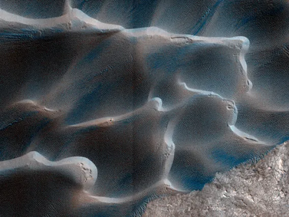
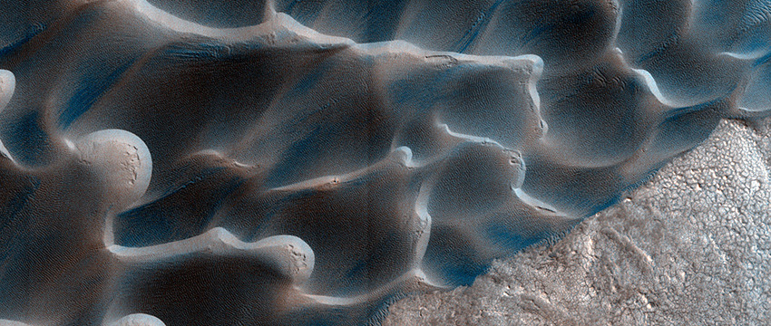
On Mars, Sands Shift to a Different Drum
In the most detailed analysis of how sands move around on Mars, a team of planetary scientists led by LPL found that processes not involved in controlling sand movement on Earth play major roles on Mars.
By Daniel Stolte, University Communications - May 22, 2019
In the most detailed analysis of how sands move around on Mars, a team of planetary scientists led by the UA found that processes not involved in controlling sand movement on Earth play major roles on Mars.
Wind has shaped the face of Mars for millennia, but its exact role in piling up sand dunes, carving out rocky escarpments or filling impact craters has eluded scientists until now.
In the most detailed analysis of how sands move around on Mars, a team of planetary scientists led by Matthew Chojnacki at the University of Arizona Lunar and Planetary Lab set out to uncover the conditions that govern sand movement on Mars and how they differ from those on Earth.
The results, published in the current issue of the journal Geology, reveal that processes not involved in controlling sand movement on Earth play major roles on Mars, especially large-scale features on the landscape and differences in landform surface temperature.
"Because there are large sand dunes found in distinct regions of Mars, those are good places to look for changes," said Chojnacki, associate staff scientist at the UA and lead author of the paper, "Boundary conditions controls on the high-sand-flux regions of Mars." "If you don't have sand moving around, that means the surface is just sitting there, getting bombarded by ultraviolet and gamma radiation that would destroy complex molecules and any ancient Martian biosignatures."
Compared to Earth's atmosphere, the Martian atmosphere is so thin its average pressure on the surface is a mere 0.6 percent of our planet's air pressure at sea level. Consequently, sediments on the Martian surface move more slowly than their Earthly counterparts.
The Martian dunes observed in this study ranged from 6 to 400 feet tall and were found to creep along at a fairly uniform average speed of two feet per Earth year. For comparison, some of the faster terrestrial sand dunes on Earth, such as those in North Africa, migrate at 100 feet per year.
"On Mars, there simply is not enough wind energy to move a substantial amount of material around on the surface," Chojnacki said. "It might take two years on Mars to see the same movement you'd typically see in a season on Earth."
Planetary geologists had been debating whether the sand dunes on the red planet were relics from a distant past, when the atmosphere was much thicker, or whether drifting sands still reshape the planet's face today, and if so, to what degree.
"We wanted to know: Is the movement of sand uniform across the planet, or is it enhanced in some regions over others?" Chojnacki said. "We measured the rate and volume at which dunes are moving on Mars."
The team used images taken by the HiRISE camera aboard NASA's Mars Reconnaissance Orbiter, which has been surveying Earth's next-door neighbor since 2006. HiRISE, which stands for High Resolution Imaging Science Experiment, is led by the UA's Lunar and Planetary Laboratory and has captured about three percent of the Martian surface in stunning detail.
The researchers mapped sand volumes, dune migration rates and heights for 54 dune fields, encompassing 495 individual dunes.
"This work could not have been done without HiRISE," said Chojnacki, who is a member of the HiRISE team. "The data did not come just from the images, but was derived through our photogrammetry lab that I co-manage with Sarah Sutton. We have a small army of undergraduate students who work part time and build these digital terrain models that provide fine-scale topography."
Across Mars, the survey found active, wind-shaped beds of sand and dust in structural fossae – craters, canyons, rifts and cracks – as well as volcanic remnants, polar basins and plains surrounding craters.
In the study's most surprising finding, the researchers discovered that the largest movements of sand in terms of volume and speed are restricted to three distinct regions: Syrtis Major, a dark spot larger than Arizona that sits directly west of the vast Isidis basin; Hellespontus Montes, a mountain range about two-thirds the length of the Cascades; and North Polar Erg, a sea of sand lapping around the north polar ice cap. All three areas are set apart from other parts of Mars by conditions not known to affect terrestrial dunes: stark transitions in topography and surface temperatures.
"Those are not factors you would find in terrestrial geology," Chojnacki said. "On Earth, the factors at work are different from Mars. For example, ground water near the surface or plants growing in the area retard dune sand movement."
On a smaller scale, basins filled with bright dust were found to have higher rates of sand movement, as well.
"A bright basin reflects the sunlight and heats up the air above much more quickly than the surrounding areas, where the ground is dark," Chojnacki said, "so the air will move up the basin toward the basin rim, driving the wind, and with it, the sand."
Understanding how sand and sediment move on Mars may help scientists plan future missions to regions that cannot easily be monitored and has implications for studying ancient, potentially habitable environments.
Researchers Find Ice Feature on Saturn’s Giant Moon
Rain, seas and a surface of eroding organic material can be found both on Earth and on Saturn’s largest moon, Titan. However, on Titan it is methane, not water, that fills the lakes with slushy raindrops.
By Mikayla Mace, University Communications - April 29, 2019
Rain, seas and a surface of eroding organic material can be found both on Earth and on Saturn’s largest moon, Titan. However, on Titan it is methane, not water, that fills the lakes with slushy raindrops.
While trying to find the source of Titan's methane, University of Arizona researcher Caitlin Griffith and her team discovered something unexpected – a long ice feature that wraps nearly half way around Titan.
Griffith, a professor in the UA Lunar and Planetary Laboratory, is the lead author on the paper published today in Nature Astronomy.
On Titan, atmospheric methane molecules are continuously broken apart by sunlight. The resulting atmospheric haze settles to the surface and accumulates as organic sediments, rapidly depleting the atmospheric methane.
This organic veneer is made up of the material of past atmospheres.
There is no obvious source of methane, except from the evaporation of methane from the polar lakes. But Titan’s lakes contain only one-third of the methane in Titan’s atmosphere and will be exhausted soon by geological time scales.
One theory is that the methane could be supplied by subsurface reservoirs that vent methane into the atmosphere. Prior studies of Titan indicate the presence of a singular region called Sotra, which looks like cryo-volcano, with icy flow features.
Griffith’s team set out to study the composition of Titan’s surface, partly hoping to find subtle small cryo-volcanos candidates. They analyzed half of Titan’s surface and none were detected, but Sotra was found to be exceptional in that it exhibits the strongest ice features.
Yet the major ice feature the researchers found was completely unexpected. It consists of a linear ice corridor that wraps around 40 percent of Titan's circumference.
“This icy corridor is puzzling, because it doesn’t correlate with any surface features nor measurements of the subsurface," Griffith said. "Given that our study and past work indicate that Titan is currently not volcanically active, the trace of the corridor is likely a vestige of the past. We detect this feature on steep slopes, but not on all slopes. This suggests that the icy corridor is currently eroding, potentially unveiling presence of ice and organic strata.”
The team’s analysis also indicates a diversity of organic material in certain regions. These surface deposits are of interest because laboratory simulations of Titan’s atmosphere produce biologically interesting compounds such as amino acids.
Griffith analyzed tens of thousands of spectral images taken of the topmost layer of the surface by Cassini’s Visible and Infrared Mapping Spectrometer, using a method that enabled the detection of weak surface features.
This feat was accomplished by Griffith’s application of the principal components analysis, or PCA. It allowed her to tease out subtle features caused by ice and organic sediments on Titan’s surface from the ubiquitous haze and more obvious surface features. Instead of measuring the surface features individually for each pixel in an image, the PCA uses all of the pixels to recognize the main and more subtle signatures.
Griffith’s team compared their results with past studies including the Huygens probe, which landed on Titan in 2005. The comparison validated both the technique and the results. Plans are underway to use the technique to explore the poles where methane seas reside.
“Both Titan and Earth followed different evolutionary paths, and both ended up with unique organic-rich atmospheres and surfaces,” Griffth said. “But it is not clear whether Titan and Earth are common blueprints of the organic-rich of bodies or two among many possible organic-rich worlds.”
A portion of the funding for this research came from NASA space grants.
What Deep Learning Reveals About Saturn’s Storms
A new technique allows researchers to dive deep into the ringed-giant's atmosphere to gain insights into Saturn's storms on a large-scale.
By Mikayla Mace, University Communications - April 29, 2019
A "deep learning" approach to detecting storms on Saturn is set to transform our understanding of planetary atmospheres, according to University College London and University of Arizona researchers.
The new technique, called PlanetNet, identifies and maps the components and features in turbulent regions of Saturn’s atmosphere, giving insights into the processes that drive them.
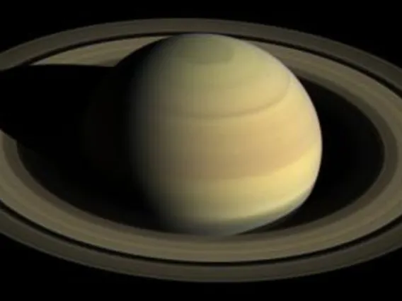
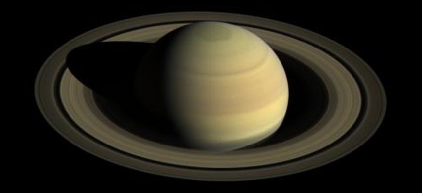
A study, published today in Nature Astronomy, provides results from the first demonstration of the PlanetNet algorithm. The results clearly show the vast regions affected by storms and that dark storm clouds contain material swept up from the lower atmosphere by strong vertical winds.
Developed by UA and UCL researchers, PlanetNet was trained and tested using infrared data from the Visible and Infrared Mapping Spectrometer instrument on Cassini, a joint mission between NASA, the European Space Agency and the Italian Space Agency.
A dataset containing multiple, adjacent storms observed at Saturn in February 2008 was chosen to provide a range of complex atmospheric features to challenge PlanetNet’s capabilities.
“PlanetNet enables us to analyze much bigger volumes of data, and this gives insights into the large-scale dynamics of Saturn,” said UA professor Caitlin Griffith, who co-authored the paper. “The results reveal atmospheric features that were previously undetected. PlanetNet can easily be adapted to other datasets and planets, making it an invaluable potential tool for many future missions.”
Previous analysis of the dataset indicated a rare detection of ammonia in Saturn’s atmosphere, in the form of an S-shaped cloud.
The map produced through PlanetNet shows that this feature is a prominent part of a much larger upwelling of ammonia ice clouds around a central dark storm. PlanetNet identifies similar upwelling around another small storm, suggesting such features are quite common.
The map also shows pronounced differences between the center of storms and the surrounding areas, indicating that the eye gives a clear view into the warmer, deep atmosphere.
“Missions like Cassini gather enormous amounts of data, but classical techniques for analysis have drawbacks, either in the accuracy of information that can be extracted or in the time they take to perform. Deep learning enables pattern recognition across diverse, multiple data sets,” said Ingo Waldmann, lead author and deputy director of the UCL Centre for Space and Exoplanet Data.
“This gives us the potential to analyze atmospheric phenomena over large areas and from different viewing angles, and to make new associations between the shape of features and the chemical and physical properties that create them,” he said.
Initially, PlanetNet searches the data for signs of clustering in the cloud structure and gas composition. For areas of interest, it trims the data to remove uncertainties at the edges and runs a parallel analysis of the spectral and spatial properties. Recombining the two data streams, PlanetNet creates a map that presents quickly and accurately the major components of Saturn’s storms with unprecedented precision.
PlanetNet’s accuracy has been validated on Cassini data not included in the training phase. The whole dataset has also been rotated and resampled to create synthetic data for further testing. PlanetNet has achieved over 90 percent classification accuracy in both test cases.
The project received funding from the European Research Council and the Science and Technology Funding Council.