Optical Sciences Student Off to Japan for Space Mission
By Amee Hennig, UA
By Amee Hennig, UA College of Optical Sciences - May 31, 2018
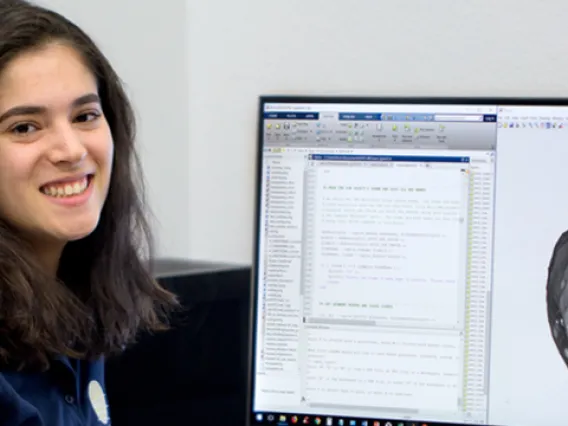
Adriana Mitchell, an undergraduate in the University of Arizona's College of Optical Sciences and Honors College who has been working with assistant professor Vishnu Reddy at the Lunar and Planetary Laboratory, is this year's sole UA recipient of the Barry M. Goldwater Scholarship and Excellence in Education. And soon she will be on her way to Japan for a unique opportunity.
The Goldwater Scholarship Program, one of the oldest and most prestigious national scholarships in the natural sciences, engineering and mathematics, seeks to identify and support college sophomores and juniors who show exceptional promise in the aforementioned fields. The scholarship provides a maximum of $7,500 per year to the student for educational expenses.
Mitchell has big plans for her future, and the Goldwater Scholarship could help those dreams come true.
"My professional aspiration is to manage NASA research missions to worlds with astrobiological implications," she says. "To reach my goal, I must first obtain a Ph.D. and learn the inner workings of interplanetary spacecraft missions."
This summer, Mitchell will travel to Japan to work with the Japan Aerospace Exploration Agency, or JAXA, on the Hayabusa2 project, a sample return mission to asteroid Ryugu. Hayabusa2 is the sister project to the UA-led OSIRIS-REx mission by NASA.
Mitchell will be at JAXA headquarters during the approach and arrival phases of the mission, assisting with the creation of digital terrain models, which she says is "a direct application of my current research on asteroids at the University of Arizona." Lucille Le Corre, a NASA-funded co-investigator on the Hayabusa2 mission, will mentor Mitchell.
The opportunity was supported and encouraged by Reddy, who is Mitchell's mentor at the UA.
"She had been working with me for a year as a NASA Space Grant intern and she wanted to do something different for her study abroad, working on a real spacecraft mission," says Reddy, who worked to organize the collaboration with Le Corre. "I'm very proud of her, and she's always been a go-getter. It is a privilege to work with talented undergraduate students like Adriana."
Mitchell, who will leave for Japan on June 27, says, "This would not be possible without the Goldwater Foundation's support and opportunities provided by my mentors here."
Mitchell previously worked with Matt Penn at the National Solar Observatory on a research project, "Polar Plume Dynamics of the Indonesian 2016 Total Solar Eclipse," to determine the true speed of solar winds. The project was presented by Mitchell at two conferences, including the 2017 Graduate and Professional Student Council Student Showcase and the 229th meeting of the American Astronomical Society.
She also has published in journals and presented at other conferences in her growing research career. She has presented research at the Crossroads Eclipse 2017 Research Workshop, the 2017 Eclipse Science Showcase and the 12th American Physical Society Conference for Undergraduate Women in Physics.
Air Force Research Lab, Others Tap UA Space Expertise
By Emily Litvack, UA
By Emily Litvack, UA Research, Discovery and Innovation - May 8, 2018
If we spent 60 years leaving every car that runs out of gas on the side of the highway to rust and crumble, as defunct machinery is wont to do, then our highways would look something like outer space does. Since the Soviet Union flung Sputnik I into low-Earth orbit in 1957, dozens of other countries have sent Earth-orbiting satellites into space with no way to retrieve them when they eventually, inevitably break down.
And, of course, there are no police in space.
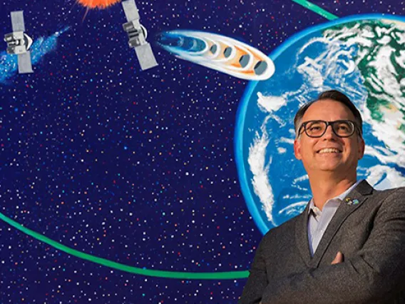
Consequently, space is more congested, contested and, in some ways, more dangerous than ever. With a total of $6.65 million in new funding, University of Arizona researchers are working to make space a safer place for our nation's satellites.
As part of the University of Arizona's Cluster Hiring Initiative jointly administered by the provost and the Office of Research, Discovery and Innovation, the UA hired five new faculty members in 2016-2017 with expertise in space situational awareness, or SSA — an emerging research area focused on identifying, characterizing and understanding the behavior of objects in space.
The initiative was dubbed SSA-Arizona, and the idea behind it was to reinforce the UA's existing strength in space science — strength such as managing more than 20 telescopes across the world, contributing to nearly every NASA space exploration mission, discovering more than half of all near-Earth objects and running Steward Observatory, which now uses both optical and radio instruments to characterize objects in space.
The new awards — a $3.3 million cooperative agreement with the Air Force Research Laboratory, a $350,000 award from DARPA, and a $3 million sub-award from Lockheed Martin — collectively represent the first major return on the UA's investment in SSA.
Building a Collaborative Infrastructure
The first of the three awards, from the Air Force Research Laboratory, or AFRL, is designed make it easier for the "Five Eyes" — an international alliance among Australia, Canada, New Zealand, the United Kingdom and the U.S. — to share data and surveil satellites. The project is led by the director of SSA-Arizona, Roberto Furfaro.
With help from Furfaro and a team of UA researchers, AFRL will have a new cyberinfrastructure for collaboration with its Five Eyes allies.
"One part of space situational awareness is trying to find out where things are in space, what their intent is and who are the operators executing that intent," says Vishnu Reddy, an assistant professor of planetary sciences hired in the group of five. "Another issue is managing traffic in space so that things don't hit each other."
The U.S. and its allies are interested in both the national security and environmental aspects of SSA. By leveraging CyVerse, the UA's existing, NSF-funded computational infrastructure to handle huge datasets and complex analyses, they will have what Reddy calls "a digital playground" for collaboration on this front.
"We're going to be able to offer (AFRL) the best possible cyberinfrastructure," Furfaro says. "I think it'll set a new standard for this kind of work. It'll be a collaborative environment where they can seamlessly drop data, make discoveries and acquire knowledge in SSA."
The multimillion-dollar cooperative agreement initially will last for three years, with the potential for further funding thereafter.
Getting Dying Satellites to the Graveyard
The next of the new grants comes from the Department of Defense's Defense Advanced Research Projects Agency, or DARPA. The $350,000, one-year project is led by UA optical scientist Michael Hart.
"Space has become more useful to us as space-based technology develops, and, as a result, it's become rapidly more crowded," Hart says. "Space has become rather full of junk over the last 60 years and it's continuing to get worse, so there's a pressing need to change the way we behave."
One of our most harmful behaviors takes place in the geostationary orbit, or GEO, a little slice of space above the Earth's equator rotating in the same direction as Earth. From Earth, satellites in GEO appear to stand still. Commercial satellites, for uses such as television and GPS, have to be in GEO, so that they have a clear and constant line of sight to your home or car.
For both commercial and government interests, "slots in geostationary orbit are limited, and highly coveted," Hart says.
But satellites go defunct after about 15 years; they can't withstand the toxic solar radiation they encounter for much longer. When they're dead, we have no way of controlling them, so they accumulate as clutter in GEO — literally, wasted space.
The DARPA-funded project is aimed at creating ways to detect a satellite on its way out before it has actually died, so that those who own the satellite have time to direct it to what's called a graveyard orbit — one that is away from common operational orbits such as GEO — before it's too late.
The technology involves measuring vibrations of a satellite that are imprinted on the reflected sunlight that lets us see them.
"In the same way wine glasses 'clink' in different ways, satellites all have different solar panels and antennae that vibrate in different ways," Hart says.
But because that unique vibration remains constant — there's no sense of speed or wind in space to change it — a technology that carefully monitors even the most minute changes in vibration will help operators recognize when not all is right with their satellite, and send it to a designated graveyard before it is defunct and unresponsive.
Taking Clear Pictures of Far-Away Technology
The third and final award — a three-year, $3 million contract with Lockheed Martin — is aimed at taking high-resolution photos of satellites in GEO.
"This project is focused on the same kind of problem as the DARPA-funded project," Hart says. "It's about understanding the health, status and behavior of satellites in the geostationary regime."
While measuring changes in vibration "promises to give us very useful information, in some sense, there's nothing better than an honest-to-goodness picture," he says.
But because these satellites are so far away from Earth, taking photos of them is no walk in the park.
"You'd need an awfully powerful telescope to take a high-resolution picture," Hart says.
The research team led by Hart will develop a small-scale prototype for combining light from several telescopes spread apart from one another and using them to piece together high-resolution images.
Leading the Way in SSA
While there is little precedent for any one of the new projects in the emerging science of SSA, the researchers believe the UA is best suited for the challenge.
"The University should be really proud of the investment it's made in SSA," Reddy says. "This is a really tough nut to crack. It's a huge risk to push for this cluster hire, and this is the first time we're demonstrating major success and that we can do this work collaboratively."
"In this case, the word 'unique' really applies," Hart says. "There's no other university in the world that can match the assemblage of infrastructure and human talent in all things space. We know what it means to operate in space, and it's a very natural arena for the UA to be engaged in."
New Estimates of Mercury's Thin, Dense Crust
By Emily Walla, UA
By Emily Walla, UA/NASA Space Grant Intern, University Communications - April 24, 2018
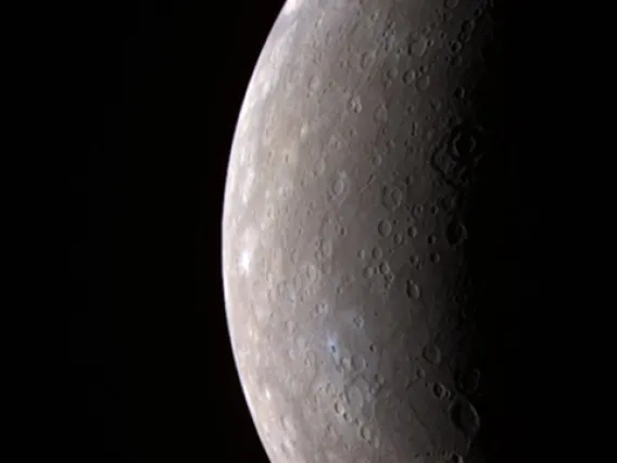
Mercury is small, fast and close to the sun, making the rocky world challenging to visit. Only one probe has ever orbited the planet and collected enough data to tell scientists about the chemistry and landscape of Mercury's surface. Learning about what is beneath the surface, however, requires careful estimation.
After the probe's mission ended in 2015, planetary scientists estimated Mercury's crust was roughly 22 miles thick. One University of Arizona scientist disagrees.
Using the most recent mathematical formulas, Lunar and Planetary Laboratory associate staff scientist Michael Sori estimates that the Mercurial crust is just 16 miles thick and is denser than aluminum. His study, "A Thin, Dense Crust for Mercury," will be published May 1 in Earth and Planetary Science Letters and is currently available online.
Sori determined the density of Mercury’s crust using data collected by the Mercury Surface, Space Environment and Geochemistry Ranging (MESSENGER) spacecraft. He created his estimate using a formula developed by Isamu Matsuyama, a professor in the Lunar and Planetary Laboratory, and University of California Berkeley scientist Douglas Hemingway.
Sori's estimate supports the theory that Mercury's crust formed largely through volcanic activity. Understanding how the crust was formed may allow scientists to understand the formation of the entire oddly structured planet.
“Of the terrestrial planets, Mercury has the biggest core relative to its size,” Sori said.
Mercury's core is believed to occupy 60 percent of the planet’s entire volume. For comparison, Earth’s core takes up roughly 15 percent of its volume. Why is Mercury’s core so large?
“Maybe it formed closer to a normal planet and maybe a lot of the crust and mantle got stripped away by giant impacts,” Sori said. “Another idea is that maybe, when you're forming so close to the sun, the solar winds blow away a lot of the rock and you get a large core size very early on. There’s not an answer that everyone agrees to yet.”
Sori’s work may help point scientists in the right direction. Already, it has solved a problem regarding the rocks in Mercury's crust.
Mercury's Mysterious Rocks
When the planets and Earth's moon formed, their crusts were born from their mantles, the layer between a planet's core and crust that oozes and flows over the course of millions of years. The volume of a planet's crust represents the percentage of mantle that was turned into rocks.
Before Sori's study, estimates of the thickness of Mercury's crust led scientists to believe 11 percent of the planet's original mantle had been turned into rocks in the crust. For the Earth's moon – the celestial body closest in size to Mercury – the number is lower, near 7 percent.
"The two bodies formed their crusts in very different ways, so it wasn't necessarily alarming that they didn't have the exact same percentage of rocks in their crust," Sori said.
The moon's crust formed when less dense minerals floated to the surface of an ocean of liquid rock that became the body's mantle. At the top of the magma ocean, the moon's buoyant minerals cooled and hardened into a "flotation crust." Eons of volcanic eruptions coated Mercury's surface and created its "magmatic crust."
Explaining why Mercury created more rocks than the moon did was a scientific mystery no one had solved. Now, the case can be closed, as Sori's study places the percentage of rocks in Mercury's crust at 7 percent. Mercury is no better than the moon at making rocks.
Sori solved the mystery by estimating the crust's depth and density, which meant he had to find out what kind of isostasy supported Mercury's crust.
Determining Density and Depth
The most natural shape for a planetary body to take is a smooth sphere, where all points on the surface are an equal distance from the planet's core. Isostasy describes how mountains, valleys and hills are supported and kept from flattening into smooth plains.
There are two main types isostasy: Pratt and Airy. Both focus on balancing the masses of equally sized slices of the planet. If the mass in one slice is much greater than the mass in a slice next to it, the planet’s mantle will ooze, shifting the crust on top of it until the masses of every slice are equal.
Pratt isostasy states that a planet’s crust varies in density. A slice of the planet that contains a mountain has the same mass as a slice that contains flat land, because the crust that makes the mountain is less dense than the crust that makes flat land. In all points of the planet, the bottom of the crust floats evenly on the mantle.
Until Sori completed his study, no scientist had explained why Pratt isostasy would or wouldn't support Mercury's landscape. To test it, Sori needed to relate the planet’s density to its topography. Scientists had already constructed a topographic map of Mercury using data from MESSENGER, but a map of density didn't exist. So Sori made his own using MESSENGER's data about the elements found on Mercury's surface.
“We know what minerals usually form rocks, and we know what elements each of these minerals contain. We can intelligently divide all the chemical abundances into a list of minerals," Sori said of the process he used to determine the location and abundance of minerals on the surface. "We know the densities of each of these minerals. We add them all up, and we get a map of density.”
Sori then compared his density map with the topographic map. If Pratt isostasy could explain Mercury’s landscape, Sori expected to find high-density minerals in craters and low-density minerals in mountains; however, he found no such relationship. On Mercury, minerals of high and low density are found in mountains and craters alike.
With Pratt isostasy disproven, Sori considered Airy isostasy, which has been used to make estimates of Mercury's crustal thickness. Airy isostasy states that the depth of a planet's crust varies depending on the topography.
"If you see a mountain on the surface, it can be supported by a root beneath it," Sori said, likening it to an iceberg floating on water.
The tip of an iceberg is supported by a mass of ice that protrudes deep underwater. The iceberg contains the same mass as the water it displaces. Similarly, a mountain and its root will contain the same mass as the mantle material being displaced. In craters, the crust is thin, and the mantle is closer to the surface. A wedge of the planet containing a mountain would have the same mass as a wedge containing a crater.
“These arguments work in two dimensions, but when you account for spherical geometry, the formula doesn’t exactly work out,” Sori said.
The formula recently developed by Matsuyama and Hemingway, though, does work for spherical bodies like planets. Instead of balancing the masses of the crust and mantle, the formula balances the pressure the crust exerts on the mantle, providing a more accurate estimate of crustal thickness.
Sori used his estimates of the crust's density and Hemingway and Matsuyama's formula to find the crust's thickness. Sori is confident his estimate of Mercury's crustal thickness in its northern hemisphere will not be disproven, even if new data about Mercury is collected. He does not share this confidence about Mercury's crustal density.
MESSENGER collected much more data on the northern hemisphere than the southern, and Sori predicts the average density of the planet's surface will change when density data is collected over the entire planet. He already sees the need for a follow-up study in the future.
The next mission to Mercury will arrive at the planet in 2025. In the meantime, scientists will continue to use MESSENGER data and mathematical formulas to learn everything they can about the first rock from the sun.
UA Researchers Track Chinese Space Station as it Falls to Earth
By Emily Litvack -
By Emily Litvack - March 22, 2018
A defunct Chinese space station, Tiangong-1, is expected to fall to Earth any day now – on March 31, give or take a few days. When it does, it'll be the largest manmade object to re-enter Earth's atmosphere in a decade.
As the day draws near, Vishnu Reddy, University of Arizona assistant professor of planetary sciences, and Tanner Campbell, an aerospace and mechanical engineering graduate student, are tracking its reentry using a $1,500 optical sensor they built in four months.
Tiangong-1 Zooms through Low Earth Orbit
Launched in 2011, Tiangong-1 served as a laboratory for three manned missions and was initially intended to deorbit in 2013. Now as it tumbles, seemingly uncontrollably, through space, researchers across the globe are scrambling to predict when and where it’ll come back down.
Tiangong-1 occupies low Earth orbit, or LEO. LEO is relatively close to Earth's surface compared to other orbits, such as medium Earth orbit and geostationary orbit, a faraway space here communication satellites reside.
For many reasons, it's harder to track and predict the path of objects in LEO than their more distant counterparts, because "objects are moving really fast," Reddy says. At 17,400 mph, Tiangong-1 orbits the Earth every 90 minutes.
On top of that, objects in LEO are up against something called "drag" when they get closer to the Earth – the faster an object travels, the harder it is for it to move through air. In the same way a hand held outside the window of a car going 70 mph is harder to control than one outside of a car going 20 mph, the same goes for Tiangong-1 as it re-enters Earth's atmosphere. Drag makes prediction harder.
Because of the harshness of LEO's environment, no spacecraft stays there forever; Tiangong-1's seven-year flight isn't unusually short.
Tracking Objects in LEO
As of now, researchers primarily track and predict paths of objects in LEO using ground-based radar systems that detect and catalog objects.
It's an extremely expensive operation available only to a select handful of countries whose militaries can afford it. The United States Air Force is one of them, with its highly sophisticated Space Fence.
"Tracking objects with radar is a very expensive exercise," Reddy says.
When the news of Tiangong-1's re-entry to Earth hit the stands, Reddy saw an opportunity to try tracking it with something less sophisticated, and less expensive. He wondered, "From the UA, can we do something meaningful to contribute to our national security interests?"
He and Campbell spent four months designing and building the $1,500 hardware and software optical sensor system to test that very question. They've been collecting data on Tiangong-1's whereabouts for several weeks.
"Over the past few weeks, it's been losing altitude rapidly," Campbell says. As of March 21, it's at an altitude of roughly 136 miles.
As Reddy and Campbell have collected and studied their data, they've been comparing it to orbit data that the Air Force has been publishing daily, gathered using radar.
"Obviously we're not going to be able to get as accurate and precise data as they can get, but we are trying to see what we can get and how closely our derived products match," Campbell says. "A system like ours is a lot more accessible to academia who can also contribute."
"It's giving an opportunity for our students to play a role in space situational awareness," says Reddy.
Taking the Results to the Real World
Reddy and Campbell explain that, for now, they're simply putting their optical sensor system to the test and seeing what it's capable of – a test for which Tiangong-1 is the perfect subject.
"Radar has advantages and disadvantages, as does optical," Reddy says. "If we've come up with something that's even half as good as radar but can be done at a tenth of the cost, there might be some problems we can solve this way."
Reddy uses the example of placing one of these systems at every fire station in the United States. Whereas radar must be manned and operated, the optical sensors can run autonomously and can effectively crowdsource similar data.
"Exactly," Campbell says. "We're not trying to replace radar, but it’s a complement."
Reddy and Campbell are now placing an array of these sensors on a single mount to be installed at Biosphere 2 – all for the purpose of tracking objects in LEO.
"Basically, we're trying to develop methods that are cost-effective for the taxpayer, train the next generation of scientists and engineers like Tanner, and show the world that we can be better stewards of our precious orbital space," says Reddy.
Campbell plans to present the results of their work tracking Tiangong-1 at the Advanced Maui Optical and Space Surveillance Technologies Conference this fall.
LPL Astronomers Track Tesla Roadster in Space
By Emily Walla, UA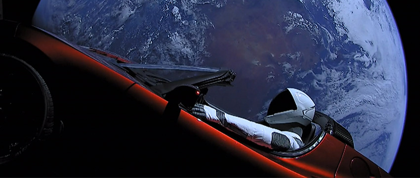
By Emily Walla, UA/NASA Space Grant Communications Intern - February 20, 2018
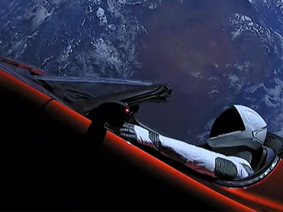
Earlier this month, the Falcon Heavy rocket successfully launched a Tesla Roadster into orbit around the sun. In the days following the launch, University of Arizona astronomers pointed their telescopes toward the car as it sped through space.
Telescopes operated by UA's Catalina Sky Survey, or CSS, were among the first to spot the Roadster, which was given the official designation of 2018-017A. Their observations immediately were submitted to the Minor Planet Center, an organization that determines the orbits of small astronomical objects such as asteroids, comets ... and the Roadster. Once the orbit of the Roadster is known, the CSS researchers can determine where it will be at any given time.
"It's the natural asteroids we are seeking to discover, not artificial satellites, but we still must know where the artificial objects are," said CSS senior research specialist Greg Leonard. The Roadster will be added to CSS' list of man-made objects so that in the future, astronomers will not mistake the car for a never-before-documented asteroid.
CSS' mission is to discover and catalog near-Earth objects. An important aspect of the mission is to identify objects that pose potential impact threats to Earth. Because the Roadster was launched from Earth, its orbit intersects Earth's. The car might come crashing back to Earth one day, or it might be nudged into an orbit that keeps it far away from Earth.
"One of the challenges of predicting the impact is that we don't know the orbit really well right now," said Eric Christensen, lead investigator for CSS. "We've only been able to observe it for a week or so."
What astronomers do know is what the Roadster will not do.
"It's not going to behave like an asteroid," Christensen said.
Astronomers have well-developed models that can be used to determine the paths of near-Earth asteroids or man-made spacecrafts, but the Roadster is an object that had not traveled through space before. No astronomer has ever had to predict how a car orbits the sun.
"Did they deflate the tires? Is air going to leak out and cause some strange thrusts? We don't know," Christensen said.
The sun also might move the Roadster onto a different course. The car is not heavy when compared to large asteroids, so radiation from the sun can push it around. Objects absorb light from the sun and re-emit this light as heat, which provides a small boost to the object. For lightweight objects, such as small asteroids, spacecrafts and space-faring cars, this small boost is sometimes enough to move the object into a different orbit.
The Roadster's current trajectory will take it in an orbit that crosses Mars' path. At its greatest distance from Earth, the car will be 250 million miles away. Even for the most powerful telescopes, detecting something so tiny at such a great distance is impossible. In a matter of weeks, the Roadster will be too far away to detect.
The observations taken while the car is still visible may be the only ones astronomers will be able to get for a long time. It takes 18 months for the Roadster to cruise around the sun, so at this time next year the car will still be millions of miles away from Earth. It may be centuries before the car and Earth meet again.
As well as being scientifically valuable, the nights spent tracking the Roadster were special occasions.
"These observations were fun," Christensen said.
"It's not every day when we attempt to acquire an image of a cherry-red Tesla Roadster hurtling into outer space," Leonard said.
The Roadster is only 13 feet long — minuscule for an astronomical object — and at a distance of more than more than 2 million miles, telescopes cannot discern the details of the car.
"Although the recovery images show only a sequence of bright blips of light moving against a starry background, knowing what the object is was really quite thrilling, as this special launch and mission marks a milestone in human capability for space exploration," Leonard said.
The Falcon Heavy rocket is the first private craft capable of carrying heavy payloads to space — and the first rocket that can send passengers to the moon since NASA retired its Saturn V rocket more than 40 years ago. And the Falcon Heavy is relatively cheap: While the Saturn V's launches each cost more than $180 million in 1969 dollars (more than $1 billion today), launching the Falcon Heavy rocket costs only $90 million.
"It's more than a gimmick," Christensen said. "It's a very significant cost-saving method."
The Catalina Sky Survey is funded by NASA and based at the UA's Lunar and Planetary Laboratory. The survey has discovered more than 8,000 near-Earth asteroids since 1998.
UA Researchers on Winning Team in Lunar Exploration Competition
By Emily Dieckman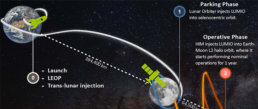
By Emily Dieckman, UA College of Engineering - February 9, 2018
Pink Floyd aside, there isn't actually a dark side of the moon — just a side you can't see from Earth. That is, unless you're a researcher like those at the University of Arizona and partnering institutions, who are setting out to investigate meteoritic impact on the far side of the moon.
The Lunar Meteoroid Impacts Observer, or LUMIO, project is headed by Francesco Topputo, an assistant professor in aerospace systems at Polytechnic University of Milan in Italy.
Roberto Furfaro, associate professor in the Department of Systems and Industrial Engineering and Department of Aerospace and Mechanical Engineering, and Vishnu Reddy, assistant professor at the Lunar and Planetary Laboratory, make up the UA team of the LUMIO mission study.
The project aims to use an advanced camera to monitor meteorites striking the moon. Combined with existing Earth-based monitoring, these observations could create a more complete picture of what happens when meteorites hit the lunar surface, and of the spatial distribution of these impacts. Understanding where meteorites that hit the moon come from — and when they hit — helps us understand the debris environment in near-Earth space.
"LUMIO will enable us to answer some key questions about small object population around the Earth-moon system," said Reddy, who came up with the science justification for the mission.
Also involved are Delft University of Technology in the Netherlands, École polytechnique fédérale de Lausanne in Switzerland, Italian aerospace and defense company Leonardo, Science & Technology Corp. in Norway, and the European Space Agency's European Space Research and Technology Center in the Netherlands.
Calling All CubeSats
SysNova, a European Space Agency initiative that uses technology challenges to attract the best proposals from European companies, universities and research centers, first asked for proposals for its Lunar CubeSats for Exploration competition in late 2016, and about 60 teams answered the call. In spring 2017, four teams were selected as finalists, receiving grants of about $100,000 and six months for initial studies. LUMIO was selected as the winner in December.
CubeSats are miniature satellites made up of 10-by-10-by-10-centimeter cubic units called U's. Originally used in university settings so students could design and run their own missions, CubeSats' low cost, low weight and increasingly powerful processing capabilities have been receiving more attention from national space agencies in recent years. Roger Walker, a project manager for educational satellite projects at the European Space Agency, compared the standard satellites of today to PCs and CubeSats to smartphones.
"Now agencies are exploring the feasibility of sending these cubes out not just around Earth, but to explore other areas," Furfaro said.
Kevin Jacquinot, who earned his master's degree in aerospace systems at the UA in 2017, designed a CubeSat for an independent study course working for Furfaro. After graduation, he did some systems engineering for LUMIO.
"Because of LUMIO, I was put in contact with the European Space Agency, and I'm actually waiting for an answer from them about working on another lunar exploration project," he said. "I would love to work on a project like this again."
As director of the Space Situational Awareness Arizona initiative, Furfaro works with other UA faculty to understand and characterize the behavior of objects in space.
One aim of the LUMIO mission is to increase lunar situational awareness, or what might impact the moon. This could be particularly important for the U.S., in light of a directive President Donald Trump signed in December formally instructing NASA to send more astronauts to the moon.
"If we're going to go back to the moon, like the president announced, we have to also have a better understanding of the moon environment," Furfaro said.
As winners of the challenge, the LUMIO team will conduct a concurrent engineering study with ESA in the coming months.
"Then, if everything goes well, there'll be a good chance we're going to fly it," Furfaro said.
Mission to the Moon
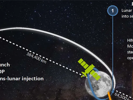
LUMIO would be about 12U (2Ux2Ux3U) and weigh about 50 pounds (roughly one-hundredth the weight of NASA's New Frontier spacecraft). In phase one of its mission, it would be transported to the moon on another vehicle, then begin its lunar, or selenocentric, orbit.
In phase two, the transfer phase, LUMIO would travel beyond the moon to L2, a gravitational parking spot that astrodynamicists refer to as a "Lagrange point" (named for an 8th-century mathematician), which will allow LUMIO to maintain its relative position to the moon as it orbits the earth.
In phase three, the operative phase, LUMIO would begin orbiting L2 in approximately 29-day rotations — the same length as the lunar cycle itself.
In the two weeks surrounding the far side's new moon — a full moon from Earth's perspective — the moon will be dark enough for LUMIO to observe and record meteoric impacts. The moon will be too bright to observe during the other two weeks, so scientists will use the time to recalibrate LUMIO's navigation system and keep it on the right trajectory.
LUMIO would orbit L2 for about a year, followed by disposal, which may involve crashing LUMIO onto the lunar surface. Another spacecraft with the right instrumentation could gain valuable information about the moon's subsurface by observing the debris and materials stirred up by LUMIO upon impact.
Rapid Detection and Recovery: The Science of Hunting Meteorites
By Emily Walla, NASA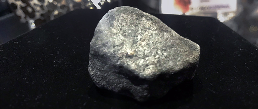
By Emily Walla, NASA Space Grant Intern, University Communications - February 6, 2018
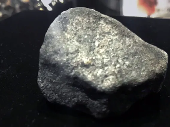
At 8:10 p.m. on Jan. 16, hundreds of people in Michigan reported the bright glow of a meteor streaking through the sky, rattling windows as it broke the sound barrier. The meteor then broke apart in the Earth's atmosphere, and its pieces rained quietly to the ground.
Using predictions by the Rapid Detection and Recovery of Meteorites, or RADARMET, project, scientists and meteorite hunters were able to recover more than half a dozen fragments of the rock within two days of the fall.
RADARMET is led by Vishnu Reddy, assistant professor in the University of Arizona's Lunar and Planetary Laboratory. He procured funding from NASA to operate RADARMET, which uses National Weather Service Doppler radar data and computer models to locate meteorites within hours of their fall.
"Historically, people would see a meteor in the sky and they would say, 'I saw it go that way behind the tree,'" Reddy said. "Even if someone takes a picture of the meteor, using the image to trace a trajectory for the meteorite is difficult and can be quite time-consuming."
Upper-atmosphere winds make extrapolation challenging, Reddy said. For a meteor to survive the trip through the atmosphere and fall onto the ground as a meteorite, it has to slow from its cosmic velocity. The friction from the atmosphere makes the meteor glow visibly between 30 and 65 miles above ground.
"Typically, meteorite-dropping meteors need to slow down to around 6,700 mph, the speed when they no longer glow brightly while descending into the atmosphere," Reddy said.
Falling at Terminal Velocity
The meteor then enters a period known as "dark flight," during which it falls at terminal velocity. During this dark flight, winds in the upper atmosphere can buffet the meteorite miles away from where its glowing bright flight ends.
Marc Fries, Reddy's co-investigator for RADARMET and a scientist at NASA's Johnson Space Center, developed a method that can predict how a meteorite would travel during its dark flight. He also has developed software tools to calculate where meteorites land under the influence of winds, and to estimate the total mass that reaches the ground.
Tanner Campbell, a UA graduate student in aerospace and mechanical engineering, adapted Fries' dark flight model into a computer program that quickly and accurately determines where a meteorite will fall.
"We can accomplish this because the kinetics of an object in near freefall are known quite well," Campbell said. "Since these meteorites are typically fairly small, we can make some assumptions about how they travel through the atmosphere. We can then take whatever data can be gathered on the meteorite while it is glowing in the sky, and measured atmospheric data from near the event, and use it to predict the path to the ground."
Atmospheric data include wind speeds and information collected by weather radar stations, which detect anything falling through the air, whether it is rain, birds, airplanes or meteorites. Although the radar cannot distinguish between a sparrow and a space rock, the RADARMET team has a method to do just that.
"The first trigger is eyewitness reports from the public," Reddy said.
Using an online tool on the American Meteor Society website, members of the public can log their location, which direction they were facing and how long the meteor was visible in the sky. When an event has corroborating videos and other evidence such as sonic booms, Reddy and his co-investigators download radar data from the nearest weather station and power up the dark flight model.
Accuracy of Location Is Vital
Within hours of the event, the RADARMET team can locate the exact area where meteorite fragments have fallen. The information is quickly shared with the public, including scientists and meteorite hunters. RADARMET's method is so accurate that hunters have been able to travel to a location, park their cars and find meteorites within that parking lot.
When hunting meteorites, time is of the essence. The sooner a sample is found, the more scientists can learn from it.
"The longer a meteorite sits on the Earth, the less scientifically useful it becomes, because the weathering process degrades the minerals and destroys it," Reddy said.
Rain can dissolve and wash away minerals, microbes can contaminate any evidence of the building blocks of life, and oxygen can rust the iron in the meteorite within a day.
Although recovering pieces of the Michigan meteorite took slightly more than a day, some samples were found in nearly pristine condition. One piece was found in ice, protected from exposure to liquid water. Pristine samples such as this one enable scientists to study materials that are easily destroyed or of astrobiological significance.
Reddy and students in the UA Department of Planetary Sciences plan to be involved in the study of the meteorite.
"While we're not out there hunting the meteorites, we're doing the science," Reddy said.
Steep Slopes on Mars Reveal Structure of Buried Ice
By University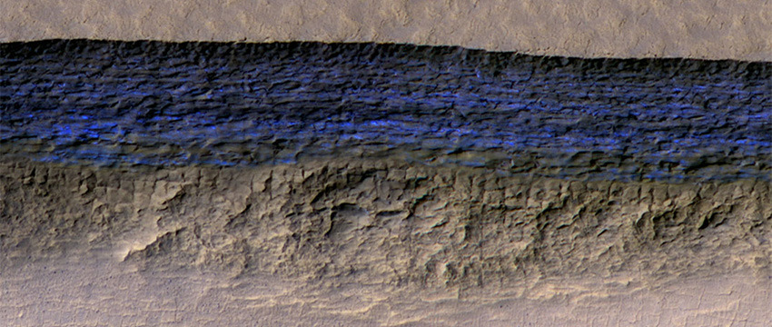
By University Communications - January 12, 2018
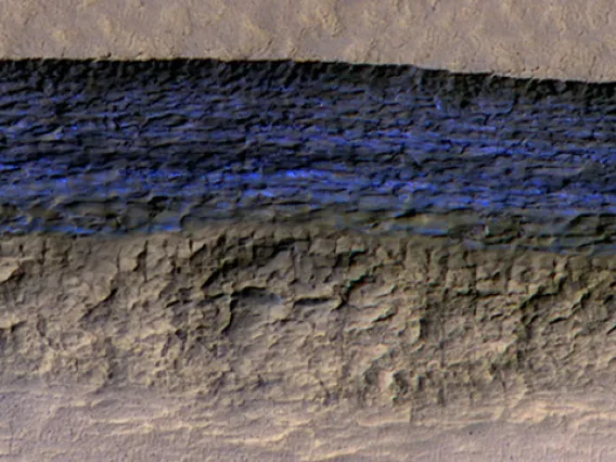
Researchers using the University of Arizona-led HiRISE camera aboard NASA's Mars Reconnaissance Orbiter, or MRO, have found eight sites where thick deposits of ice beneath Mars' surface are exposed in faces of eroding slopes.
These eight scarps, with slopes as steep as 55 degrees, reveal new information about the internal layered structure of previously detected underground ice sheets in Mars' middle latitudes.
The ice was likely deposited as snow long ago. The deposits are exposed in cross section as relatively pure water ice, capped by a layer 1 to 2 yards (or meters) thick of ice-cemented rock and dust. They hold clues about Mars' climate history. They also may make frozen water more accessible than previously thought to future robotic or human exploration missions.
Researchers who located and studied the scarp sites with the HiRISE, or High Resolution Imaging Science Experiment, camera on MRO reported the findings on Jan. 11 in the journal Science. The sites are in both the northern and southern hemispheres of Mars, at latitudes from about 55 to 58 degrees, equivalent on Earth to Scotland or the tip of South America.
"There is shallow ground ice under roughly a third of the Martian surface, which records the recent history of Mars," said the study's lead author, Colin Dundas, of the U.S. Geological Survey's Astrogeology Science Center in Flagstaff, Arizona. "What we've seen here are cross sections through the ice that give us a 3-D view with more detail than ever before."
Windows Into Underground Ice
The scarps directly expose bright glimpses into vast underground ice previously detected with spectrometers on NASA's Mars Odyssey orbiter, with ground-penetrating radar instruments on MRO and on the European Space Agency's Mars Express orbiter, and with observations of fresh impact craters that uncover subsurface ice. NASA sent the Phoenix lander to Mars in response to the Odyssey findings; in 2008, the Phoenix mission confirmed and analyzed the buried water ice at 68 degrees north latitude, about one-third of the way to the pole from the northernmost of the eight scarp sites.
"The discovery gives us surprising windows where we can see right into these thick underground sheets of ice," said Shane Byrne of the UA Lunar and Planetary Laboratory, a co-author on the new report. "It's like having one of those ant farms where you can see through the glass on the side to learn about what's usually hidden beneath the ground."
Scientists have not determined how these particular scarps initially form. However, once the buried ice becomes exposed to Mars' atmosphere, a scarp likely grows wider and taller as it "retreats," due to sublimation of the ice directly from solid form into water vapor. At some of them, the exposed deposit of water ice is more than 100 yards, or meters, thick. Examination of some of the scarps with MRO's Compact Reconnaissance Imaging Spectrometer for Mars, or CRISM, confirmed that the bright material is frozen water. A check of the surface temperature using Odyssey's Thermal Emission Imaging System, or THEMIS, camera helped researchers determine they're not seeing just thin frost covering the ground.
Researchers previously used MRO's Shallow Radar, or SHARAD, to map extensive underground water-ice sheets in middle latitudes of Mars and estimate that the top of the ice is less than about 10 yards beneath the ground surface. How much less? The radar method did not have sufficient resolution to say. The new ice-scarp studies confirm indications from fresh-crater and neutron-spectrometer observations that a layer rich in water ice begins within just 1 or 2 yards of the surface in some areas.
Astronauts' Access to Martian Water
The new study not only suggests that underground water ice lies under a thin covering over wide areas, it also identifies eight sites where ice is directly accessible, at latitudes with less hostile conditions than at Mars' polar ice caps.
"Astronauts could essentially just go there with a bucket and a shovel and get all the water they need," Byrne said.
The exposed ice has scientific value apart from its potential resource value because it preserves evidence about long-term patterns in Mars' climate. The tilt of Mars' axis of rotation varies much more than Earth's, over rhythms of millions of years. Today the two planets' tilts are about the same. When Mars tilts more, climate conditions may favor buildup of middle-latitude ice. Dundas and co-authors say that banding and color variations apparent in some of the scarps suggest layers "possibly deposited with changes in the proportion of ice and dust under varying climate conditions."
This research benefited from coordinated use of multiple instruments on Mars orbiters, plus the longevities at Mars now exceeding 11 years for MRO and 16 years for Odyssey. Orbital observations will continue, but future missions to the surface could seek additional information.
"If you had a mission at one of these sites, sampling the layers going down the scarp, you could get a detailed climate history of Mars," suggested MRO deputy project scientist Leslie Tamppari of NASA's Jet Propulsion Laboratory in Pasadena, California. "It's part of the whole story of what happens to water on Mars over time: Where does it go? When does ice accumulate? When does it recede?"
The UA operates HiRISE, which was built by Ball Aerospace & Technologies Corp. of Boulder, Colorado. The Johns Hopkins University Applied Physics Laboratory, Laurel, Maryland, leads MRO's CRISM investigation. The Italian Space Agency provided MRO's SHARAD instrument; Sapienza University of Rome leads SHARAD operations; and the Planetary Science Institute, based in Tucson, leads U.S. involvement in SHARAD. Arizona State University leads the Odyssey mission's THEMIS investigation. JPL, a division of Caltech in Pasadena, California, manages the MRO and Odyssey projects for the NASA Science Mission Directorate in Washington. Lockheed Martin Space, Denver, built both orbiters and supports their operation.
UA in the Running for a New NASA Mission
By University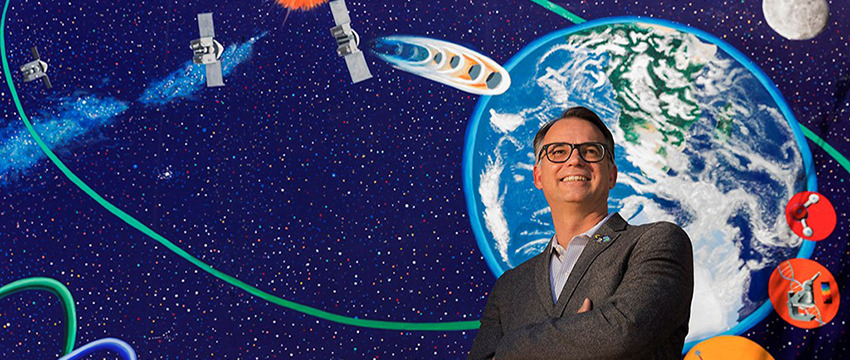
By University Communications - December 21, 2017
NASA has chosen a planetary mission involving a team from the University of Arizona as one of two finalists to be the next robotic solar system explorer. The proposed mission, named CAESAR, for Comet Astrobiology Exploration Sample Return, seeks to return a sample from a comet to determine its origin and history.
UA Lunar and Planetary Laboratory professor Dante Lauretta is CAESAR's mission sample scientist, responsible for leading the analysis of the returned comet sample. He also is tasked with advising on all aspects of the mission's design that influence the scientific value and integrity of the sample. Lauretta is currently principal investigator of NASA's OSIRIS-REx asteroid sample return mission, which launched in September 2016 and will return NASA's first asteroid sample to Earth in 2023.
LPL associate professor Tom Zega is a co-investigator on the CAESAR mission and would analyze the comet sample material once it is back on Earth. Zega, currently a collaborator on the OSIRIS-REx mission, will be one of the first scientists to analyze samples from the asteroid Bennu.
"We are excited to bring the UA's leadership in sample science innovation to the challenges posed by the CAESAR mission and its target comet," Lauretta said. "The work done on CAESAR will ensure that the UA continues to stand at the forefront of extraterrestrial sample analysis for the next 20 years."
If selected, CAESAR would be the fourth mission in NASA's $1 billion New Frontiers program, which sends robotic spacecraft to conduct science-intensive planetary investigations. The UA leads the third New Frontiers mission, OSIRIS-REx, currently on its way to the asteroid Bennu to retrieve a sample of its surface for study on Earth.
"This is a wonderful opportunity to apply the experience that the UA has gained from OSIRIS-REx to another frontier in planetary science," said Kimberly Andrews Espy, UA senior vice president for research. "We are delighted to be able to continue the University's tradition of leadership in exceptional NASA missions."
CAESAR's target comet is 67P/Churyumov-Gerasimenko, which previously was explored by the European Space Agency's Rosetta spacecraft. If the mission is ultimately chosen, the CAESAR spacecraft could launch by 2025 and return to Earth in 2038. The mission is led by Steve Squyres of Cornell University and managed by NASA's Goddard Space Flight Center. NASA intends to make the final mission selection in summer 2019. Between now and then, the two finalist missions will receive funding from NASA to further advance the missions' concepts and designs.
The other finalist mission, Dragonfly, is led by LPL alumna Elizabeth Turtle, who earned her Ph.D. in planetary science in 1998 and then continued at LPL as both a postdoctoral fellow and as research faculty before joining the Johns Hopkins University Applied Physics Laboratory in Laurel, Maryland. The Dragonfly spacecraft is a dronelike rotorcraft that would explore the prebiotic chemistry and habitability of dozens of sites on Saturn's moon Titan, an ocean world in our solar system.
UA Students Participate in First Global Planetary Defense Exercise
By Emily Walla, NASA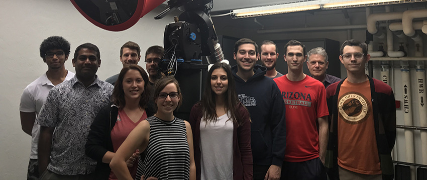
By Emily Walla, NASA Space Grant Intern, University Communications - December 4, 2017
University of Arizona students recently took part in a NASA-led international exercise that used a real asteroid flyby to test global planetary defense capabilities. The project was designed to exercise how astronomers' efficiency in determining the orbit, rotation, shape, size and composition of an asteroid that could potentially impact the Earth. The campaign was led by Vishnu Reddy, assistant professor in the UA's Lunar and Planetary Laboratory.
The exercise's target was the asteroid 2012 TC4. The small asteroid — only 50 feet long and 25 feet wide — was on course to closely approach Earth. On Oct. 12, TC4 safely passed the planet, coming within 27,200 miles of the surface (that's about 5,000 miles above the orbit of geostationary satellites). In the months before the flyby, astronomers from the U.S., Canada, Colombia, Germany, Israel, Italy, Japan, the Netherlands, Russia and South Africa tracked TC4 using ground- and space-based telescopes from around the world.
Planning for the so-called TC4 Observation Campaign started in April, under the sponsorship of NASA's Planetary Defense Coordination Office. The exercise commenced in earnest in late July, when the European Southern Observatory's Very Large Telescope spotted the asteroid. The finale was a close approach to Earth in mid-October.
Graduate and undergraduate students at the UA were given the opportunity to participate in the project as part of a class Reddy taught with Walt Harris, professor in the Department of Planetary Sciences.
Using observations collected during the campaign, scientists at NASA's Jet Propulsion Laboratory, or JPL, were able to precisely calculate TC4's orbit, predict its flyby distance on Oct. 12 and rule out the possibility of a collision between Earth and the asteroid.
RAPTORS Network Put to Use
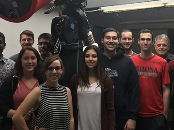
A network of telescopes, including the student-built Rapid Astronomical Pointing Telescopes for Optical Reflectance Spectroscopy, or RAPTORS, housed on the UA campus, was used to study how fast TC4 rotates. Given that TC4 is small, astronomers expected it to be rotating fast. They were surprised to find that the object was not only spinning once every 12 minutes, it also was tumbling.
A team of UA undergraduate students from Reddy's class observed the asteroid using RAPTORS.
"Observing using RAPTORS went beautifully," said Collin Lewin, one of Reddy's undergraduate students. "The opportunity to operate a telescope like RAPTORS is rare for undergraduates, so this was a valuable experience for many students."
Finding out what TC4 is made of turned out to be more challenging. Is the asteroid rich in carbon, or does it consist of bright rocky materials? Infrared observations made with NASA's Infrared Telescope Facility, or IRTF, at the Mauna Kea Observatory in Hawaii would allow scientists to identify the asteroid's composition. On a trip funded by the Lunar and Planetary Laboratory's external advisory board, graduate students from the UA traveled to Hawaii to perform the necessary observations.
The work done by Reddy's students would allow NASA to know exactly what materials comprised which parts of the asteroid. Although they were able to collect some data before the asteroid's close approach, adverse weather conditions and technical difficulties prevented Reddy's graduate students at IRTF from taking observations during TC4's flyby on Oct. 12.
"Something always goes wrong. You have to learn how to deal with it," said Cassandra Lejoly, a doctoral student in Reddy's class.
Others in Reddy's class, such as doctoral student Ben Sharkey, noted that the experience was useful for students who were unsure of the direction in which they wished to take their careers.
"This experience gave them an idea of what observing takes. It might help those students decide if they want to have to deal with the difficulties that come with observing," Sharkey said.
"Whether or not our graduate students are going to use telescopes in their professional careers, they are going to work with people who do," said Timothy Swindle, director of the Lunar and Planetary Laboratory. "One of the important things in a graduate student's education is learning about the tools that you use, and the tools used by the people you work with. This was one opportunity for them to see how a telescope really works."
Rare Opportunity for Students
Most observing can be done remotely, as the telescopes can send data to computers far from the observatories.
"Learning how to use a telescope as complicated as IRTF is something that few people get to do in person," said Teddy Kareta, a first-year doctoral student at LPL. Witnessing the inner workings of the telescope granted students such as Kareta a deeper understanding and respect for the instruments and the people who operate and repair them.
"No one expected the observing trip to be quite as tumultuous as it was, but the students learned that when trying to do great things, they will face setbacks along the way," Swindle said.
Although the setbacks at IRTF threw a small wrench in the observation campaign, scientists at JPL were nevertheless able to determine what materials were present at the surface of the asteroid. Radar scattering properties of TC4 are consistent with a bright, rocky surface, similar to a particular class of meteorites that reflect 50 percent of light that hits them.
In addition to the observation campaign, NASA used this exercise to test communications between the many observers and also to test internal U.S. government messaging and communications up through the executive branch and across government agencies. Such would be necessary during an actual impact emergency.
"We demonstrated that we could organize a large, worldwide observing campaign on a short timeline, and communicate results efficiently," Reddy said.