LPL Fieldtrip Spring 2016
Many LPL field trips could be retitled “Effects of the Farallon Plate Subduction,” and this spring’s trip to the San Bernardino Valley and Chiricahua Mountains was no exception. For three days (Feb. 26-28), LPL field trip group (PTYS 594A) explored an area shaped by the volcanic and tectonic consequences of plate subduction in addition to the consequences of changing water availability.
On day one, our group stopped at the spheroidally weathered rocks off the I-10 freeway (east toward New Mexico) before moving on to Willcox Playa, where we discussed how playas form and searched for signs of large desiccation cracks, drying due to climate change, and signs of earth fissures. Earth fissures in Arizona are caused by subsidence due to artificial groundwater pumping, a process so far constrained to the Earth. We also discussed the biological and human history of the area, noting that Geronimo, the Apache leader, surrendered on what is now private land not far from the field trip route.
Day two was focused more on the consequences of the Farallon Plate subduction, including the basin and range province formation and the multiple episodes of volcanism. We saw cinder cones and maar craters, and reviewed the formation of mantle xenoliths, discussing the consequences of the still-active basin and range formation in the Southwest (including an 1887 earthquake that had its epicenter in Mexico but was still felt in Tucson). Field trippers also took the opportunity to discuss border issues, which seemed especially pertinent as later that day, we saw a mounted border patrol officer making rounds.
Finally, on day three, we drove across the Chiricahua Mountains and arrived at the national monument. Our hikes brought us close to hoodoos as well as precariously balanced rocks (PBRs), resulting in discussion about their formation in tuff deposits from a large eruption about 30 million years ago, similarly timed to the formation of some of the cinder cones observed the day before. Due to construction within the national monument, there were features that we were unable to see, including fossil fumaroles, but our group discussed them and the economic role that the volcanic activity has played in Arizona’s history (Arizona has high grade copper deposits that are still being mined).
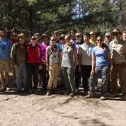 |
The Spring 2016 LPL field trip group photo at Chiricahua National Monument. (Photo credit: Hamish Hay) |
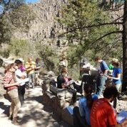 |
The field trip group listens to talks about the formation of the Turkey Creek volcanic deposit, hoodoos, and precariously balanced rocks within Chiricahua National Monument. (Photo credit: Margaret Landis) |
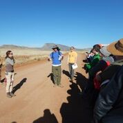 |
Shane Byrne explains to the group how plate subduction can lead to volcanic activity and basin and range terrain. (Photo credit: Margaret Landis) |