LPL Fieldtrip Fall 2015: Salton Sea
Late October saw the PTYS 594A LPL field trip group heading off for three days of exploring the area around the Salton Sea, an inland body of water caused by accidental flooding in 1905. While accidental flooding may not make for the best planetary analog, the intermittent lacustrine history of the Salton Sea area is an interesting analog to both Mars and Titan. In addition to the Salton Sea itself, the surrounding Californian landscape was also home to dunes, faults, and mud volcanoes.
On Day One, we arrived at the Salton Sea by way of the Algodones Dunes, a dune field over 700 km2 in size that has been used as a movie set and recreation area. We were interested in the dunes themselves, formed from sediment from a previous paleolake that filled, at least in three distinct times, large amounts of the Salton Trough. We also took a moment to note the tectonic history of the Salton Trough and of the general basin and range province we had just driven through (and would continue to explore the rest of the trip). We camped the first night in the Anza-Borrego Mountains and were able to identify some of the edge of the dry lakebed of Lake Cahuilla, as well as numerous shells from the last period of lake filling.
On Day Two, our group visited mud volcanoes, unique features that erupt a mix of water and sediment due to pressurization from below (in this case due to the tectonic activity of the Salton Trough). We observed the eruptions of the sludgy material that built up almost person-height structures, and had an opportunity for mud volcano kite-based stereophotogrammetry conducted by LPL Associate Staff Scientist Stephen Scheidt.
Finally, we arrived at the Salton Sea. From the mined dacite domes (a safe distance from the shore), we were able to see the large body of water, populated by pelicans and other migratory water birds. We discussed the catastrophic formation of the Salton Sea from an overflowing notch in the Colorado River 110 years ago, subsequent recreational use, and continuing salinization and eutrophication as agricultural runoff slowly becomes the inland sea's only source of water (direct water supplies will be cut off by 2018 as a drought mitigation measure). The Imperial Valley is still a major producer of dates and other crops, serving as a reminder of how human land use, the environment, and geology all play a role in changing terrestrial landscapes.
We spent our remaining time at the Salton Sea continuing to explore the dune types, dry lakebeds, and alluvial fans of the strongly tectonic and variably lacustrine environment. Our group camped at Clark Dry Lake to observe another dry lakebed and vegetated dunes. On Day Three of the field trip, we went in search of the tufa deposits left by the previous high stands of lakes in the area, observed dunes in action as they crossed a paved (and previously accessible) road, and took a few minutes to discuss the long history of humans in the Southern California coastal regions before returning to Tucson.
|
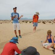
LPL graduate student Ben Lew giving a talk (Photo: M. Landis) |
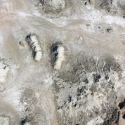 |
Raw kite image of the mud volcanoes (Photo: S. Scheidt) |
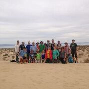 |
Group photo at a Salton Sea dune, with the inland sea in the background. (Photo: S. Byrne) |
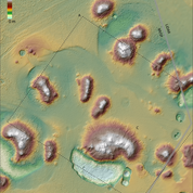 |
Map showing the digital terrain model of the mud volcanoes site. A. Dashed line shows footprint for 1 of 187 raw camera images used to calculate the topography. B. Location where spectators were standing created anomalies in the data. C. Some of the mud flows that had spilled on the northeast side of a mud volcano were expressed well in the topographic data. (Map and caption: S. Scheidt) |