By Penny Duran, NASA Space Grant Science Writing Intern, University Communications - October 25, 2023
Picture soaring over a rugged canyon on another world, strapped into an imaginary hang glider. Or getting a bird's eye view of craters that stretch on for miles and following along the same paths as the robotic rovers that have explored the surface of Mars. All of this is possible – virtually – thanks to specialists at the University of Arizona's Lunar and Planetary Laboratory.
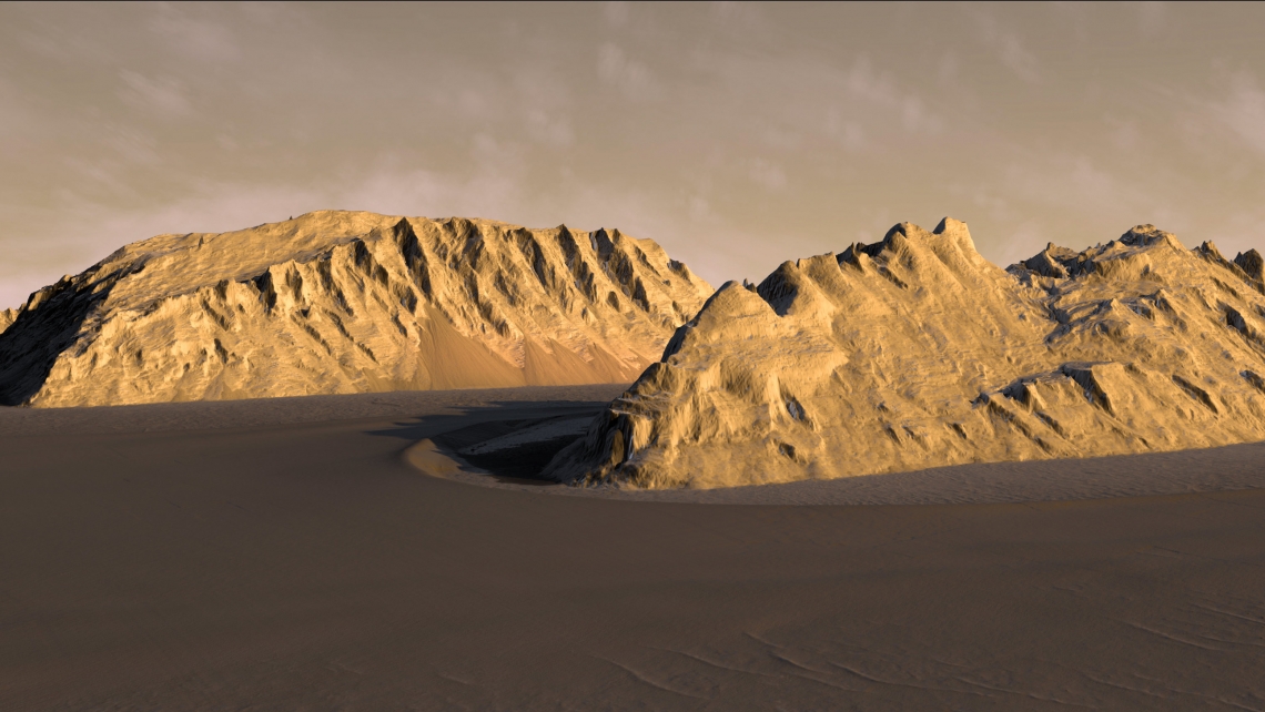
A team at the Lunar and Planetary Laboratory has created realistic terrain models of Mars' surface using specialized software and high-resolution images taken from space. Known as digital terrain models, or DTMs, these renderings allow mission planners to examine landing sites for landers and rovers and scout routes across the alien terrain, laying the groundwork for ongoing and future Mars exploration campaigns.
Creating a DTM begins with high-resolution images taken with the High Resolution Imaging Science Experiment, or HiRISE, a UArizona-led camera instrument aboard NASA's Mars Reconnaissance Orbiter, or MRO, which has captured detailed views of the red planet's surface since 2006. Unlike a consumer-grade digital camera, HiRISE does not take "snapshots" of a scene – rather, it relies on a method called push-broom photography. As the orbiter passes over Mars, the camera takes a long scan, producing pictures used to create DTMs, which are topography maps and capture the shape of planetary surfaces.

"DTMs take a long time to make," says HiRISE outreach coordinator Ari Espinoza, "so the fact we've been able to crank them out in such high numbers underscores the value that HIRISE still has – especially because no one else is making such high-resolution images of Mars' terrain."
HiRISE can resolve objects as small as three feet, about the size of a coffee table. Thus, HiRISE can reveal potential snags and obstacles in landscapes that may look deceptively easy to navigate when viewed from a distance. The sheer amount of DTMs from UArizona has made them a sought-after resource used to examine changes in Mars' geology, find safe landing sites and navigate rover routes.
For each DTM, two images of the same area are necessary. HiRISE captures each image on a separate orbit and at a different angle, and combining the images results in a so-called stereo pair.
Essentially, the set of images making up a stereo pair mimics the left eye and right eye, creating a sense of depth, explains HiRISE scientist and DTM lead Sarah Sutton.
"When you look at the images together with special glasses – like the red-blue glasses often handed out at science fairs – it allows your brain to make a 3D image," she says.
The stereo pairs are then used to produce the DTMs – an intensive process that involves a coding component, examining the actual images taken by HiRISE and editing the DTMs.
The program launched in 2008 with Sutton being the sole producer of DTMs. Thanks to a growing team that includes student workers, the effort is on track to complete more than 150 for this year alone, a record. September saw the completion of a major milestone when the number of total DTMs passed the 1,000 mark.
"Production has gotten a lot faster because we have better targeting of stereo pairs, more automation in our process, and we are continually refining our methods," Sutton says.
Editing especially requires a lot of hands-on work. For example, stark differences in lighting, such as a dark shadow covering one side of a crater, can cause errors that need to be evaluated by a human pair of eyes.

"In such cases, the computer doesn’t register what is actually on the surface, and so it makes things up that we have to correct manually," says Branden Gosse, a recent UA graduate who now works as a research technician for HiRISE.
During HiRISE's repeated passes over the same area, it sometimes witnesses changes on the Martian surface that provide valuable scientific clues about dynamic processes, Sutton explains.
"We can observe seasonal changes in frost cover or dunes moving across the land," she says. "That's only possible with DTMs, since they correct for differences due to the individual images being taken from slightly different optical perspectives."
On top of depicting surface changes, DTMs help Mars rovers navigate terrain that could be dangerous. While small, sharp rocks are too small for DTMs to resolve, they can effectively display hazardous sand dunes that rover wheels can get stuck in. In collaboration with cameras aboard rovers, DTMs can even enable almost real-time navigation of rovers' routes.
Making space science tangible
The feats accomplished through DTMs have been made possible through the scores of UArizona students who have produced them over the years, culminating in 1,000 DTMs made from a pool of almost 8,000 stereo pair images. Although DTM production has a steep learning curve, the benefits are immense and planetary science gets more tangible, according to Sutton.
"DTM production gives students the opportunity to see how space science really works outside a classroom," she says.
Simultaneously, the HiRISE team learns from students’ new perspectives, and students learn how to work with the software, according to Max Cabrera, a student worker majoring in physics and astronomy.
"Last semester, there would be this overlap where I’d use the techniques from DTM production in class and vice versa," he says. "There was this nice back and forth that helped me hone my edge for coding."
Even with a long history under their belt, DTMs cover a very small percent of Mars' surface – less than 1 or 2 percent – which highlights the extent of contributions HiRISE can continue to make for as long as the hardware lasts. With students and scientists hard at work in the DTM lab, the topography maps are bound to secure the success of Mars missions – and possibly even human space exploration in the not-too-distant future.
According to Alfred McEwen, the mission’s principal investigator, "DTMs are critical for finding future landing sites for humans or robots as well as monitoring safety and what is happening on the surface."
"Researchers for other moons and planets wish they had something like HiRISE and the MRO orbiting their field of study," McEwen says. "High-resolution images are highly desired pretty much anywhere that you have a solid surface."
Aside from HiRISE, McEwen serves as deputy principal investigator for the Europa Imaging System, or EIS, on NASA's Europa Clipper spacecraft, scheduled for launch next year. Similar to the flyovers over Mars' surface, the Clipper mission will involve studying Jupiter's moon Europa, the sixth-largest moon in the solar system, during a series of flybys.
"As the spacecraft orbits Jupiter and makes close passes to Europa, we hope to get the same kind of stunningly beautiful pictures of this icy world as we do of Mars with HiRISE," McEwen says.